Turismo de Galicia

-
Things to do
Way of St. James
Nature
Culture and heritage
Beaches and coast
Tourist trails
- Top ten: Ten unrivalled destinations
- The route of the camellia
- Tourist routes
- Pathways for discovering a country
- Walks to fall in love with
- Scenery at the wheel
- EuroVelo Galicia
- Beyond the Sunset
Gastronomy
Health tourism
PROMOTIONS TO ENJOY NOW
Cultural agenda
Will happen... View all
- Places to visit
-
Plan your trip
Build your journey
Practical information


-
A miña viaxe
A MIÑA VIAXE
- Compartir
- Correo
- Imprimir

On the Way of St. James
Description
The mountains of O Careón form the last stretch of the
demanding Camino Primitivo before it joins the Camino
Francés to Santiago. This mountain range is of moderate
height (798 m, maximum) and the subsoil has special
characteristics which make it an area of great geological
interest in Spain.
There are an abundance of small mountain rivers which run together into the river Furelos, the final tributary of the Ulla. There are also numerous hill-walking routes through the area, and even the local roads which cross the mountains are of landscape interest.
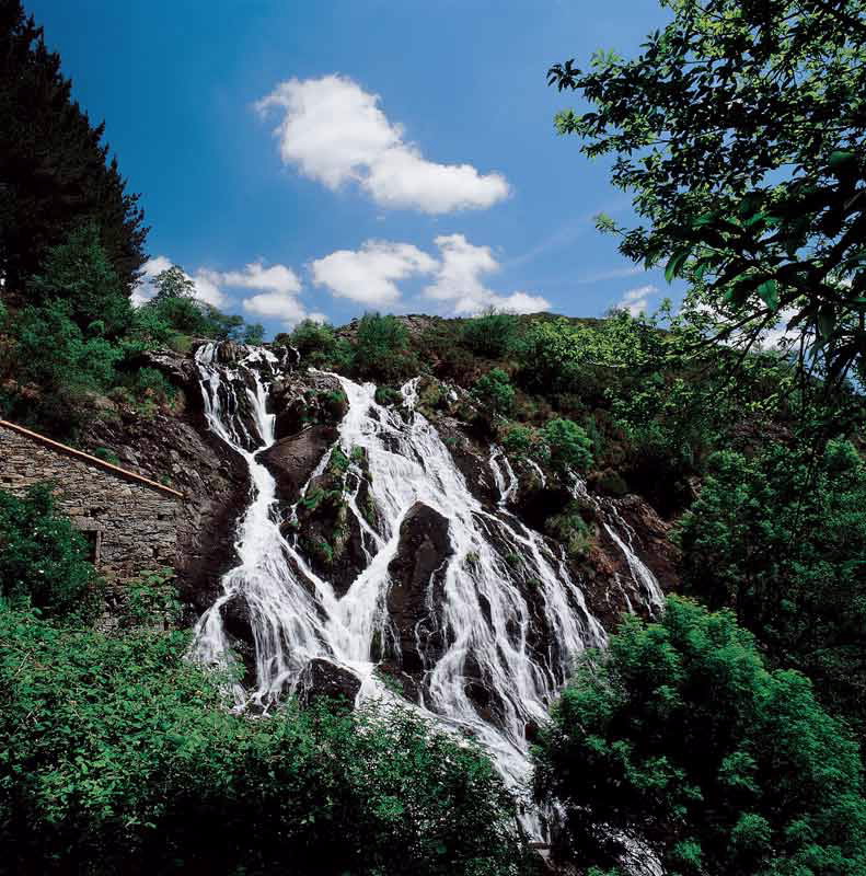
One of the most outstanding places is the shrine of San Antolín de Toques, surrounded by the forest, or the route to As Fervenzas (Toques), with its drop of some 40 metres beside an old mill.
There are an abundance of small mountain rivers which run together into the river Furelos, the final tributary of the Ulla. There are also numerous hill-walking routes through the area, and even the local roads which cross the mountains are of landscape interest.
One of the most outstanding places is the shrine of San Antolín de Toques, surrounded by the forest, or the route to As Fervenzas (Toques), with its drop of some 40 metres beside an old mill.
Access
Access via the N-547 road, from
Santiago or from Lugo; and the
AC-840 from A Coruña, via
Betanzos.
The Ways of St. James
The French Camino
The Northern Camino
The Primitive Camino
Situation
Municipalities of Melide, Santiso
and Toques in A Coruña; Friol
and Palas de Rei in Lugo;
Agolada in Pontevedra.
Area
6.567,87 hectares
Information and facilities
Aula de la Naturaleza de Toques
Telephone: +34 981 506 421
Download the coordinates for this resource...

