routenameKmlevel of difficulty
1MAQUINO LARGAÑO13,8 KmDificultad verde
2CIRCULAR DE NOGUEIRA DE RAMUÍN34,3 KmDificultad negro
3CIRCULAR DE PARADA DE SIL33,5 KmDificultad verde
4OS TORGAIS8,8KmDificultad Azul
5FÁBRICA DA LUZ12,5 KmDificultad roja
6CIRCULAR DE DOS BOSQUES E VIÑAS32 KmDificultade negro
7CIRCULAR DA TEIXEIRA11,7 KmDificultade facil
8CIRCULAR DE CASTRO CALDELAS7 KmDificultade moi facil


You can see the details of the different routes on a computer or GPS with GPX. and KMZ. files. The GPX co-ordinates are GPS data exchange files and need the right programme to import them into your GPS. The KMZ co-ordinates are files with geographical data that can be seen with the free programme Google Earth.


R1 - Maquino Largaño

R1

Maquino Largaño means ‘long path’ in Barallete, the argot once used by members of the knife-sharpening and umbrellarepair trade.

After leaving the meeting point at the Luíntra sports centre, the trail descends towards Baldomar, running through a forested area with oaks and chestnuts along a wide path with a good surface. The path then narrows and becomes more technical on the ascent.

After reaching the village of Monteverde, you can stop to visit Moura Necropolis, located 750 metres above sea level. You will see the half-buried ruins of up to seven funerary structures dating from the Neolithic Age

From here, an extremely beautiful descent along a path running between stone walls leads to San Lorenzo in Biduedo Chapel, where you will need to stop and catch your breath before tackling the climb along a paved section to Pombar. After following a stretch of the route shared with Route 2 - Nogueira de Ramuín Circular close to Cortecadela, the route continues to Alto do Bidueiro, heading towards the village of Mundín before returning to its starting point.

Along several sections, the MTB route coincides with the Maquino Largaño, Transourensán and Camino Natural de Santo Estevo trails. Caution is advised along these sections as you may encounter hikers.

 
start pointPavillón polideportivo de Luíntra
42º24'33.69" N / 007º43'21.34"W
 max. heightaltitude difference (+)distanceconnection/s
736m438m13,8 kmR2
finish_pointPavillón polideportivo de Luíntra
42º24'33.69" N / 007º43'21.34"W
min. heightaltitude difference (-)timedifficulty
563m438m1h 50 min

RELATED DOCUMENTS...

R2 - Circular de Nogueira de Ramuín

R2

This route begins at Santo Estevo de Ribas de Sil Monastery. After covering the steep gradient on the early part of the route, we recommend visiting Litoria, a castro (pre-Roman fortified settlement) just a few metres off the path, to take in the incredible panoramic view of the monastery and Sil River Canyon.

The route continues on to Cortecadela and then follows a forest track until the turn-off for A Virxe do Monte Chapel. Accompanied by the windmills of the Sil Wind Farm, the route crosses through repopulated areas of scots pine to an altitude of 1,150 metres in the Cabeza de Meda Mountains, on the boundary between the municipalities of Esgos, Xunqueira de Espadanedo and Nogueira de Ramuín.

The trail then descends to the village of O Coutiño, sharing the final metres of this section with Route 3 - Parada de Sil Circular, which ascends in the opposite direction. At this point, you can stop at the O Picotiño and Cabezoá viewpoints, which are signed along the route. Following the Transourensán Trail, this stretch of the route includes sections of track and paved trail, passing the Pé do Home Viewpoint, the village of Vilar and Santa María Church before returning to the monastery.

start pointMosteiro de Santo Estevo de Ribas de Sil
42º25´01.36” N / 007º41´11.77”W
 max. heightaltitude difference (+)distanceconnection/s
1210m990m34,3 km1, 3
fi nish pointMosteiro de Santo Estevo de Ribas de Sil
42º25´01.36” N / 007º41´11.77”W
min. heightaltitude difference (-)timedifficulty
474m-990m4h 35´very difficult

RELATED DOCUMENTS...

R3 - Ruta Circular de Parada de Sil

R3

This route begins near the town hall building in Parada de Sil, sharing its initial section with Route 4 - Os Torgais. After leaving Chamoso, the route continues on to O Couto and O Coutiño, where it connects to Route 2 - Nogueira de Ramuín Circular, which runs in the opposite direction from O Mato.

Continuing along the lower slopes of Mount Meda, along tracks and paths, the route passes through the villages of Guendón and Casa do Vento, where it begins a descent that leads to A Hedrada Reservoir. A path running parallel to the shore will take you to Pradomao, which offers a lovely panoramic view of the entire reservoir. Upon reaching Forcas Cemetery, after crossing through a small meadow, the route follows a gorgeous path which links up with Route 5 - A Fábrica da Luz and continues on to the village of Santo André.

This section of the trail passes the small settlements of Calvos, Purdeus, O Valado and A Casalta. On reaching the mills at Entrambosríos, there is a tough climb along a rocky path. We recommend porting your bike for about fifteen minutes until you reach the road to get your energy back.

The final section of the route runs along a path that climbs up to Pardela before ending in Parada de Sil.

start pointCasa do Concello de Parada de Sil
42º23´00.27” N / 007º34´19.56”W
 max. heightaltitude difference (+)distanceconnection/s
1038 m967 m33,5 km2,5
fi nish pointCasa do Concello de Parada de Sil
42º23´00.27” N / 007º34´19.56”W
min. heightaltitude difference (-)timedifficulty
363 m-967 m4h 30´very easy

RELATED DOCUMENTS...

R4 - Os Torgais Route

R4

Leave Parada de Sil at the spot known as Fondo de Vila and head towards the “Foxo do Lobo” (wolf pit) along a cart path, passing several of the chestnut drying huts known as sequeiros.

A good track leads to Os Torgais Viewpoint and then on to a spot known as “Balcones de Madrid”. This extraordinary viewpoint is where street merchants who sold rolled wafers, a profession with a long tradition in the entire Ribeira Sacra region, once bid farewell to their families. When these Parada de Sil natives set off, they would usually say that they were ‘going to Madrid’, giving one of the most extraordinary spots from which to view the Sil River Canyon its name.

After a descent along a cobbled path, the route comes to Portela. A paved trail climbs up to San Antonio Chapel. After crossing the road which leads to Santa Cristina Monastery, it continues on to the village of Santa Mariña. This section is shared with Route 3 - Parada de Sil Circular, which runs in the opposite direction. It is therefore advisable to exercise caution.

Santa Cristina Monastery is one of the most delightful spiritual centres in the Ribeira Sacra region and well worth a visit. ‘Ribas de Sil’ was added to its name in 1508, when it became part of Santo Estevo de Ribas de Sil Monastery, serving as the priorate. Apart from the history contained within its walls, the spectacular Romanesque style church with Gothic elements is especially noteworthy.

start pointCasa do Concello de Parada de Sil
42º23´00.27” N / 007º34´19.56”W
 max. heightaltitude difference (+)distanceconnection/s
671 m218 m8,8 km3
fi nish pointCasa do Concello de Parada de Sil
42º23´00.27” N / 007º34´19.56”W
min. heightaltitude difference (-)timedifficulty
546 m-218 m1h 10'

RELATED DOCUMENTS...

R5 -Fábrica da Luz Route

R5

This route has three distinguishing features: the local relief, which includes steep gradients; the Mao River Canyon, which marks the municipal boundary of A Teixeira; and the pipes leading to Regueiro Hydropower Plant, which divide the area and can only be crossed at specific points.

The route begins at the meeting point at A Fábrica da Luz, one of the first parts of Galicia’s hydroelectric infrastructure built in the early 20th century. It has now been converted into a hostel. The route then climbs three kilometres along a paved path to San Lourenzo, where it is possible to visit San Vítor Necropolis.

It then descends to the Sil River Canyon and continues on a good path along the riverbank to A Barxa, which marks the start of a climb up to A Costrela.

To cross the pipes that supply water to Regueiro Hydropower Plant, you will need to cross a small bridge and then port your bike a short distance between some of the area’s traditional vineyards.

The next section runs along a hillside on a path by the edge of the canyon, offering a view of the mouth of the Mao River where it flows into the Sil. From Barxacova, continue along the riverbank to a dirt track with a steep gradient, which ends at the road that leads back to the hostel at A Fábrica da Luz.

Before or after your ride, we recommend visiting the elevated wooden walkway along the Mao River Canyon that forms part of an easy hiking trail running from the car park at A Fábrica da Luz to Barxacova.
 

start pointAlbergue A Fábrica da Luz
42º22´27.22” N / 007º29´50.13”W
 max. heightaltitude difference (+)distanceconnection/s
581 m566 m13 km3
finish pointAlbergue A Fábrica da Luz
42º22´27.22” N / 007º29´50.13”W
min. heightaltitude difference (-)timedifficulty
229 m-566 m2hdifficulty

RELATED DOCUMENTS...

Circular de dos Bosques e Viñas

R6

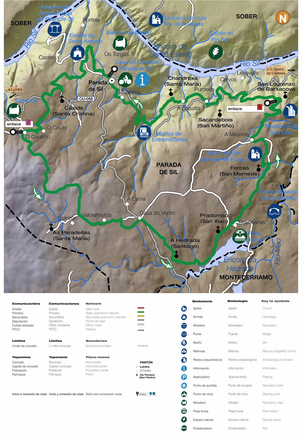
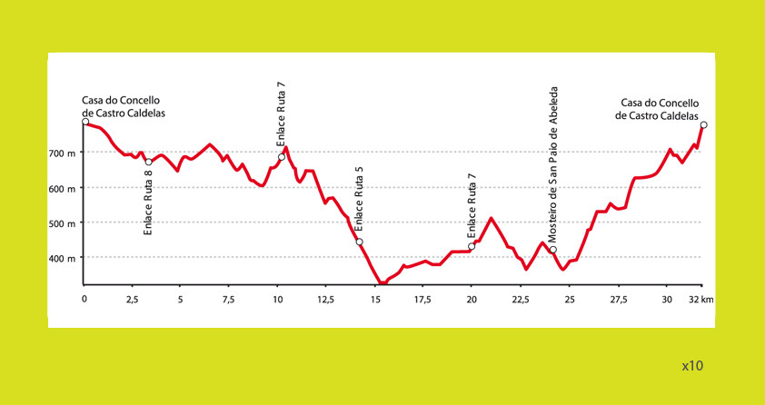
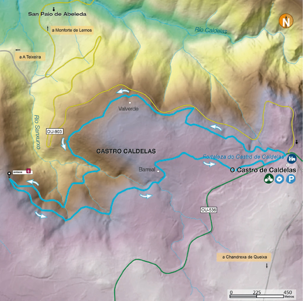
This route departs from the centre of Castro Caldelas – a town worth visiting before setting off. The old quarter, declared a historic and artistic site in 1998, consists mainly of the streets going up to the Castle of the Counts of Lemos, which follow their mediaeval course, revealing interesting stone houses adorned with galleries and coats of arms.
We cross the city centre in the direction of the small village of Barreal to venture into the lush woodland of the Poboeiros Souto (chestnut grove), where we can find several specimens of centuries-old chestnut trees.
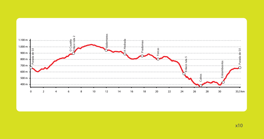
Nowadays, new trees and different plant species, above all oaks, grow alongside the majestic chestnut trees. On leaving the woodland, we continue pedalling towards the town of Poboeiros with its grandiose rectory, and then on to Boazo. We enter once again into dense Woodland until reaching a track from where we can enjoy the Abeleda Valley and an impressive view of A Teixeira. At this point of the route, there is a 2-kilometer link that allows us to get closer to the “Fábrica da Luz”, in the municipality of Parada de Sil to be able to enjoy the visit to the walkway of the Mao River and other bike routes of montaña that departs from this place. From the original route we go into the Mao Canyon and the Cristosende vineyards, rising parallel to the Sil Canyon. The route brings us back to the Abeleda Valley, which we cross through, passing the San Paio de Abeleda Monastery. Despite its state of neglect, it’s an interesting ensemble dating back to the 10th or 12th century, depending on the author.
We tackle the last part of this route by ascending through the thousand-year-old vineyards of the coast of Alais and a final stretch crossing the Edo Valley, the last few kilometres offering glimpses of Castro Caldelas in the distance

start point_Casa do Concello de Castro Caldelas
42°22’29.04”N -7°24’56.31”W
 max. heightaltitude difference (+)distanceconnection/s
783 m1045 m32 kmR5, R7, R8
finish point_Casa do Concello de Castro Caldelas
42°22’29.04”N -7°24’56.31”W
min. heightaltitude difference (-)timedifficulty
322 m1053 m4 hDificultade moi dificil

RELATED DOCUMENTS...

CIRCULAR DA TEIXEIRA

R7

Scenic route through which we can discover the three valleys surrounding this high village being an excellent natural viewpoint overlooking the Ribeira Sacra.

The route starts in the woodlands of the A Carosa before reaching Cristosende, a spectacular observation point where you can take in the sights of the surrounding scenery. From there we head into the first valley, Mao, descending among vineyards and enjoying views of the famous River Mao walkway – a wooden path stretching 1.8 kilometres we recommend you visit. We can get closer to this place by following the signposted link on a 2-kilometer route that allows us to reach the “Fábrica da Luz”, the starting point of this spectacular walkway and route 5 that belongs to the Sil del Centro BTT Ribeira stop sector sacred. From this point we face a climb parallel to the Sil Canyon where we can contemplate its famous terrace vineyards before reaching Portela. We carry on pedalling across the Abeleda Valley, which combines a long wine-growing tradition with great scenic beauty. In the last few kilometres, we’ll be able to glimpse the village of Castrocaldelas with its famous castle in the distance, before going back to A Teixeira.

start pointCasa do Concello da Teixeira
42°23’24.89”-7°28’23.43”
 max. heightaltitude difference (+)distanceconnection/s
646 m410 m11,7 kmR5, R6
finish_pointCasa do Concello da Teixeira
42°23’24.89”-7°28’23.43”
min. heightaltitude difference (-)timedifficulty
323 m412 m1,30 hDificultade facil

RELATED DOCUMENTS...

CIRCULAR DE CASTRO CALDELAS

R8

On this short route departing from the centre of O Castro de Caldelas, we’ll see woods of centuries-old chestnut trees surrounding the village. It is a very simple route suitable for all levels of difficulty. We can visit the ruins of the villages Entrambasaugas and O Rosario with its views of the Abeleda Valley. At kilometer 3, the cyclist can connect with route 6 “Circular dos bosques e viñas” and continue pedaling through this great route of the Ribeira Sacra BTT center that joins the municipalities of O Castro de Caldelas and A Teixeira.

At the height of Valverde, we can visit the chapel of San Amaro, off the route but well signposted. We carry on pedalling until heading into the Poboeiros Souto, a lush woodland where a gentle ascent starts between centuries-old chestnut trees that will accompany us until we reach the first houses of the village of O Castro de Caldelas.

start point
Casa do Concello  Castro Caldelas
42°22’29.04”-7°24’56.31”
 
max. height
altitude difference (+)
distancelink
778 m216 m7 kmR6
finish_pointCasa do Concello  Castro Caldelas
42°22’29.04”-7°24’56.31”
min. height
altitude difference (-)
timedifficulty
593 m214 m1 hDificultade moi facil

RELATED DOCUMENTS...

Arriba
Help us improve!