Turismo de Galicia

-
Things to do
Way of St. James
Nature
Culture and heritage
Beaches and coast
Tourist trails
- Top ten: Ten unrivalled destinations
- The route of the camellia
- Tourist routes
- Pathways for discovering a country
- Walks to fall in love with
- Scenery at the wheel
- EuroVelo Galicia
- Beyond the Sunset
Gastronomy
Health tourism
PROMOTIONS TO ENJOY NOW
Cultural agenda
Will happen... View all
- Places to visit
-
Plan your trip
Build your journey
Practical information


-
A miña viaxe
A MIÑA VIAXE
- Compartir
- Correo
- Imprimir

Description
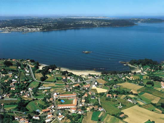
The Coitelada point in the north and the Torrella point in the south flank the entrance of a strip of sea that enters westbound and divides into two estuaries, one to the north-east and the other to the south, which like that of A Coruña, are very small: Ares and Betanzos.
Its location and its closed configuration were the reason for privileged climatic conditions characterised by mild temperatures and moderate rainfall that explain the importance that vegetable gardens and vineyards take on on the shores.
These lands, known as As Mariñas, perfectly combine tourist development and the best historical and artistic tradition materialised in the old quarters of Betanzos and Pontedeume, in the Terraza de Sada, in the Voto de Chanteiro, started in the 15th century and in the Romanic church of Bergondo, which bear witness to the growth of lands that experienced the imposition of the heraldry of the house of Andrade.
Betanzos and Pontedeume are centres of enormous artistic interest, with historical centres worthy of visit made up of narrow streets and certain sections with arcades, overlooked by beautiful buildings in granite in the form of churches and medieval fortresses such as Santa María do Azougue and San Francisco from the 14th century in the first of the towns, and the Torreon dos Andrades, built between 1370 and 1380, in the second.
Redes offers the unique silhouette of a fishing village hanging over the sea, Ares is a tourist town as is Sada and is also the leisure capital of the region, and has the Torres de Meirás in its surrounding area, a palace inhabited by Doña Emilia Pardo Bazán and later by general Franco, whereas Miño has become a place for many visitors each year in search of its beach.

