


mailto:?subject=Envio de conteúdo de Turismo de Galicia: BAIXA LIMIA-SERRA DO XURÉS&body=Recomendo-lhe que leia a informação BAIXA LIMIA-SERRA DO XURÉS extraída do portal de Turismo de Galicia na página https://www.turismo.gal/recurso/-/detalle/9607/baixa-limia-serra-do-xures?tp=1%26ctre=2
BAIXA LIMIA-SERRA DO XURÉS

Espaços naturais
Datos do recursos turístico
Posição
Ourense
Entrimo | Lobios | Muíños
Coordenadas:
41º 50' 56.7" N - 8º 04' 58.1" W
Descrição
Paisagens da “raia seca”
O rio Lima é um rio único e escavou uma passagem natural junto à qual a história foi deixando pegadas humanas. O rio recolhe um completo tecido fluvial que cai em cascatas e quedas-d’água, repousa em barragens sucessivas, atravessa uma fronteira e oferece no fim as águas ao oceano atlântico. Assim, o maior Parque Natural galego une-se ao parque de maior importância em Portugal, o Parque Nacional Peneda-Gerês. Juntos alcançam um espaço protegido de carácter transfronteiriço único na Europa.
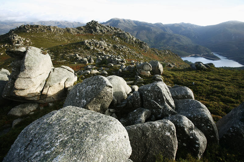
Trata-se da “raia seca”, pois o traçado fronteiriço não só se situa nos rios como também no alto das serras: O Laboreiro, Queguas e Quinxo ao norte; Santa Eufemia, O Xurés e O Pisco, ao sul. Os pontos mais elevados ascendem até aos 1.500 metros de altitude, combinam as formas suaves dos velhos montes galegos com as mais abruptas. As agulhas e bolos (pedras de granito) que o tempo encavalgou em complicados equilíbrios são as marcas de identidade da zona.
Encontraremos monumentos megalíticos, lendas de ouro e o testemunho da passagem dos legionários romanos pela calçada XVIII ou Via Nova. Ainda permanecem em pé os miliários deixados no caminho que unia as capitais romanas de Braga e Astorga pela única passagem natural entre estes montes, a mítica Portela do Home, ponto fronteiriço de acesso ao território português.
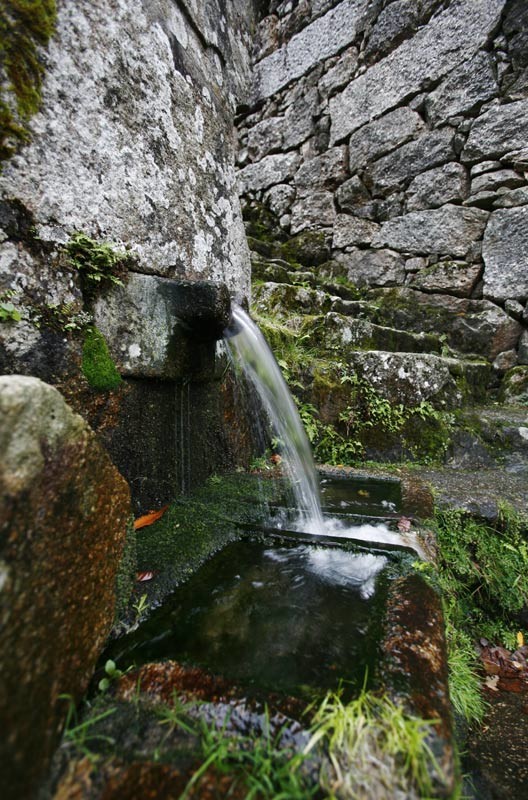
As construções populares como moinhos, colmeias amuralhadas (“alvarizas”), cabanas de pastores (“chivanas”), espigueiros, fornos, caminhos e cercas revelam a alma mais criativa dos habitantes. Um património herdado da tradição numa dúzia de núcleos rurais que, até à actualidade, mantiveram a actividade agropecuária dentro do Parque. Assim, as aldeias do Couto Misto ocuparam um território que até 1868 manteve um estatuto de privilégios independente de Espanha e Portugal.
O rio Lima é um rio único e escavou uma passagem natural junto à qual a história foi deixando pegadas humanas. O rio recolhe um completo tecido fluvial que cai em cascatas e quedas-d’água, repousa em barragens sucessivas, atravessa uma fronteira e oferece no fim as águas ao oceano atlântico. Assim, o maior Parque Natural galego une-se ao parque de maior importância em Portugal, o Parque Nacional Peneda-Gerês. Juntos alcançam um espaço protegido de carácter transfronteiriço único na Europa.
Trata-se da “raia seca”, pois o traçado fronteiriço não só se situa nos rios como também no alto das serras: O Laboreiro, Queguas e Quinxo ao norte; Santa Eufemia, O Xurés e O Pisco, ao sul. Os pontos mais elevados ascendem até aos 1.500 metros de altitude, combinam as formas suaves dos velhos montes galegos com as mais abruptas. As agulhas e bolos (pedras de granito) que o tempo encavalgou em complicados equilíbrios são as marcas de identidade da zona.
Encontraremos monumentos megalíticos, lendas de ouro e o testemunho da passagem dos legionários romanos pela calçada XVIII ou Via Nova. Ainda permanecem em pé os miliários deixados no caminho que unia as capitais romanas de Braga e Astorga pela única passagem natural entre estes montes, a mítica Portela do Home, ponto fronteiriço de acesso ao território português.
As construções populares como moinhos, colmeias amuralhadas (“alvarizas”), cabanas de pastores (“chivanas”), espigueiros, fornos, caminhos e cercas revelam a alma mais criativa dos habitantes. Um património herdado da tradição numa dúzia de núcleos rurais que, até à actualidade, mantiveram a actividade agropecuária dentro do Parque. Assim, as aldeias do Couto Misto ocuparam um território que até 1868 manteve um estatuto de privilégios independente de Espanha e Portugal.
Acesso
Desde Ourense, em direcção a Celanova e
Portugal, pela OU-540. Desde Xinzo de Limia
pela estrada municipal OU-301 até Bande.
Situação
Sudoeste da província de Ourense, fronteira
com Portugal. Nos municípios de Entrimo,
Lobios e Muíños. Além disso, os Sítios de
Importância Comunitária estendem-se pelos
municípios de Padrenda, Quintela de Leirado,
Verea, Bande, Calvos de Randín e Lobeira.
Superfície
29.762 ha.SIC: 34.248,13 ha.
Servizos
Refeições: Sim.
Alojamento: Sim.
Alojamento: Sim.
A não perder
Antes de entrar no Parque, a principal via de acesso pela estrada OU-540 oferece aos visitantes importantes paragens para
conhecer o património histórico da zona. Aquis Querquernnis é a jazida romana formada por um acampamento e uma
“mansio" viária situada à margem da barragem das Conchas, no município de Bande. Nas proximidades situa-se o moderno
Centro de Interpretação "Aquae Querquennae" - Via Nova. Dessa época também se destaca a igreja pré-românica de Santa
Comba de Bande cuja nave e as pinturas murais são de visita obrigatória.
Já no Parque existem rotas para automóveis que enlaçam os miradouros naturais e paragens significativas; uma rota equestre e muitas possibilidades de trilhos por cada uma das serras que constituem a raia. Algumas são de traçado muito exigente.
Lobios, na margem esquerda, e Entrimo, na direita, são as capitais do parque. Na vila balneária de Lobios, com as águas termais do rio Caldo, situa-se a Sede e o Centro de Interpretação. Na mesma localidade, a escassos metros do balneário, encontramos os vestígios romanos visitáveis da “mansio Aquis Originis". O trajecto pela estrada que continua desde Lobios até à passagem fronteiriça de Portela do Home permite observar desde longe a cascata da Fecha, a mais alta da Galiza, em época de chuvas, e também descobrir o conjunto de numerosos miliários da calçada romana.
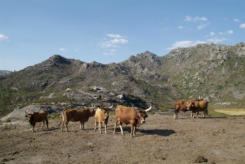
Desde A Terrachá, capital municipal de Entrimo, que conta com uma interessante igreja de fachada barroca, partem os desvios para a serra de Queguas e Quinxo. Por exemplo, o que conduz até à aldeia de Olelas, um dos melhores sítios para ver os exemplares da vaca cachena. É a raça bovina autóctone, de pequeno tamanho e grandes cornos, adaptada à dureza da serra e que nos últimos anos já não estão à beira da extinção.
Já no Parque existem rotas para automóveis que enlaçam os miradouros naturais e paragens significativas; uma rota equestre e muitas possibilidades de trilhos por cada uma das serras que constituem a raia. Algumas são de traçado muito exigente.
Lobios, na margem esquerda, e Entrimo, na direita, são as capitais do parque. Na vila balneária de Lobios, com as águas termais do rio Caldo, situa-se a Sede e o Centro de Interpretação. Na mesma localidade, a escassos metros do balneário, encontramos os vestígios romanos visitáveis da “mansio Aquis Originis". O trajecto pela estrada que continua desde Lobios até à passagem fronteiriça de Portela do Home permite observar desde longe a cascata da Fecha, a mais alta da Galiza, em época de chuvas, e também descobrir o conjunto de numerosos miliários da calçada romana.
Desde A Terrachá, capital municipal de Entrimo, que conta com uma interessante igreja de fachada barroca, partem os desvios para a serra de Queguas e Quinxo. Por exemplo, o que conduz até à aldeia de Olelas, um dos melhores sítios para ver os exemplares da vaca cachena. É a raça bovina autóctone, de pequeno tamanho e grandes cornos, adaptada à dureza da serra e que nos últimos anos já não estão à beira da extinção.
Natureza senlleira
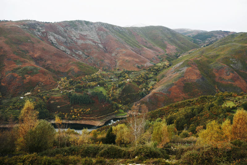
O Xurés é diverso em paisagens e vida. Zona de transição floral eurosiberiana (atlântica) e mediterrânea com a
conjugação de factores latitudinários e orientação dos vales. Nos cumes há vegetação de monte baixo e nas zonas do
vale, carvalhais e outras espécies. Importância das florestas de galeria nos cursos fluviais.
Manadas de lobo e presas. A cabra montesa é uma espécie presente num programa de reintrodução e há um projecto de recuperação do cavalo designado pónei galego ou garrano.
Manadas de lobo e presas. A cabra montesa é uma espécie presente num programa de reintrodução e há um projecto de recuperação do cavalo designado pónei galego ou garrano.
Información e equipamentos
Sede do Parque
Telefone: +34 988 448 048
Direção: Lobios
Centro de Interpretación do Parque Natural
Telefone: +34 988 448 048
Telefone 2: +34 988 448 181}
Direção: Lobios
C. Interp. Arqueolóxica Aquae Querquennae - Via Nova
Telefone: +34 988 444 401
Telefone 2: +34 988 448 181}
Direção: Porto Quintela(Bande)
Tipos de fauna
Águia-de-asa-redonda
Corço
Javali
Lobo
Peneireiro-vulgar
Tartaranhão-caçador
Outras características
Observação de pássaros
Zona ZEPA
Plano

