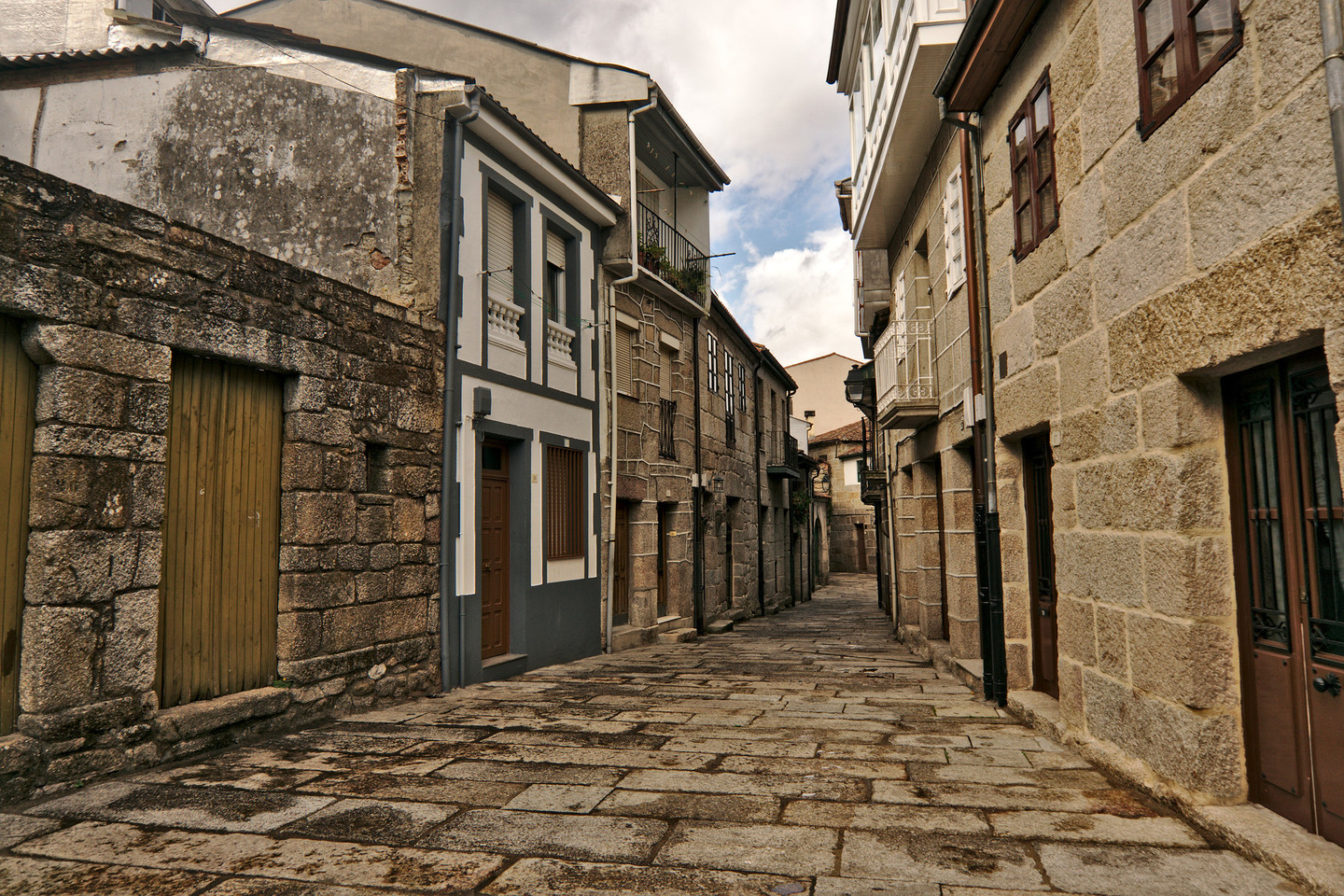
O Ribeiro – located around the middle course of the river Miño, to the west of the province of Ourense and bordering on that of Pontevedra – offers visitors a varied repertory of cultural, scenic and gastronomic attractions which make this area one of the most interesting in inland Galicia.

Its most important town is Ribadavia, well connected by motorway and train with Ourense and Vigo, from which it is 25 and 65 km away, respectively.

Water from its rivers, spas and reservoirs plays a main role in the area's personality. On their passage through these lands, the Rivers Miño, Arnoia and Avia produce successive pools and gorges, thus creating the emblematic landscape of O Ribeiro. Most of the population of the region is settled in the river valleys. The landscape we see is gentle in nature, the Faro de Avión being the highest point at 1,154 metres. Although there are no great heights, Nature has blessed the area with several viewpoints from where we can contemplate the landscape, full of vineyards and orchards, so typical of this region. There are many natural sites of great value, such as Pena Corneira and the banks of the Miño, Arnoia and Avia.

It is located in the southern part of Galicia and escapes from the influence of the Atlantic storms and also far from the harshness of the mountains, which gives this area an Oceanic-Mediterranean transition climate.

The vegetation is the result of the combined action of Nature and human influence. The first provided the necessary conditions of fertile soil and mild climate, and the second gradually adapted the environment to human needs. The lush forests follow the channels of the rivers. The vine stands out among all the crops of the area, frequently arranged in spectacular terraces. The different varieties of O Ribeiro gave these lands' wines a reputation of quality that was already recognised in times of the Roman Empire.

The passing of the centuries left a great wealth of monuments in the form of mediaeval hamlets, monasteries, churches, convents and bridges. The numerous archaeological remains, such as burial mounds, dolmens and "castros" (Celtic settlements), show us that people have been here since ancient times. During the Middle Ages, Ribadavia was home to a large Jewish community, whose influence is still felt nowadays even in the region's gastronomy. Today the, O Ribeiro offers a full range of leisure activities which include cultural events, gastronomy, recreational activities in contact with nature and hydrotherapy.
 

Route

The route we propose is of low difficulty, with the help of a vehicle and doing short journeys on foot. It is suitable for everyone and ideal to do as a family. It takes an estimated three days. The time distribution should be taken just as an example, as it can be varied according to individual preference.

Day 1

We will dedicate the first day of our route to visit the numerous tourist attractions of Ribadavia. This town, capital of O Ribeiro, is located on the confluence of the rivers Avia and Miño, on the road between Ourense and Vigo. The surrounding landscape is formed by river valleys, vineyards and rolling hills.

It was the capital of the Kingdom of Galicia under King García I in the 11th century. In the 12th century its period of commercial and demographic expansion began, thanks to the impetus of the monasteries of San Clodio and Melón. In 1164 it received the "Foro Real" (Royal Charter) and in 1375 it became the seat of the "Adelantado Mayor" (Chief Governor) of the Kingdom of Galicia.  In 1476 it became a "Villa Condal" (town where the count resides). Its economic life, very prosperous between the 15th and 17th centuries, was always linked to wine. Its wines have been famous in Europe since ancient times and were exported to the New World after the Discovery.

So many centuries of existence left an extremely rich artistic and cultural legacy in Ribadavia. In 1947, its old quarter was declared a Historical/Artistic Complex. According to the original text, this designation comprises "the town of Ribadavia, in the part between the castle and the River Avia, and the rear part of the houses constructed on the left side of the road from Villacastín to Vigo, as well as the street and the square or atrium with the church of Oliveira and the Convent of Santo Domingo with all the outbuildings, surroundings and flights of stairs accessed from the road".

O inicio perfecto para o noso percorrido é a Oficina Municipal de Turismo. Está situada na Praza Maior, no antigo Pazo Condal, unha edificación barroca do século XVII. Seranos de grande utilidade facérmonos cun pequeno plano da vila no que veñan marcados os puntos de interese. Desde alí desprazarémonos a pé, sen dificultade, entre os seus numerosos monumentos.

The perfect start for our route is the Municipal Tourist Office. It is situated in the Praza Maior, in the old Pazo Condal (Counts' Manor house), a 17th-century Baroque construction. It will be highly useful for us to pick up a small street plan of the village which marks the points of interest. From here, we can easily visit its numerous monuments on foot.

The list is extensive. Among the civil constructions we can highlight the Castle of the Counts of Ribadavia, the Jewish Quarter and the walls. The religious repertory is formed by the aforementioned Church, the Convent of Santo Domingo, the Church of Santiago, the Church of Santa María de Oliveira, the Church of San Juán and the Chapel of Nuestra Señora del Portal.

The Museo Etnolóxico (Ethnological Museum), housed in the 18th-century Pazo de Baamonde, has an excellent collection and one of the best historical library collections in Galicia. It also holds temporary exhibitions.

The Festa da Istoria (History Festival) is a celebration whose origins lie in the 17th century. It was lost in 1868 and was recovered for the enjoyment of residents and visitors in 1989. For one day, the last Saturday of August or the first of September, Ribadavia readopts the way of life of the Middle Ages. 21st-century clothes disappear and the clothing and customs of that time return. There are medieval dances and music, a market, handicraft stalls, Jewish weddings, etc. The "maravedí" (old Spanish coin) is even adopted as official currency.

Other events one should bear in mind are the Muestra Internacional del Teatro (International Theatre Festival) and the Feira do Viño do Ribeiro (Ribeiro Wine Fair).

Day 2

On the second day of our route through O Ribeiro we leave Ribadavia by the OU-504 road, in the direction of O Carballiño. Another 4.2 km further – after passing a petrol station – we reach a turnoff to the left which will lead us to Beade along the OU-212 road. The parish church of Santa María, which we will find on the right after passing through the village, is a magnificent building surrounded by vineyards. Its current appearance is due to the different stages in which it was built. The shrine of San Roque is found close to the parish church, on the other side of the grove.

This is the end point of the Way of the Cross, which begins in the atrium of the parish church and is well-known as the result of having been drawing, eminent Galician nationalist and artist of the last century. It has fourteen "cruceiros" (stone crosses) of different characteristics which are scattered about in a disorderly fashion. The Calvary shows the crucified Christ flanked by two crosses which represent the Good and the Bad Thief, differentiated by their position and their facial expression.

We continue our journey along the OU-212 road towards Berán, now in the municipality of Leiro. The turnoff which leads us to the medicinal baths is on the right, 1.2 km from the parish church of Beade. A few metres, we will find the entrance to this building – temporarily closed – that has sulphurous waters recommended for treating skin problems. Two km later we come to the village of Berán. Its points of interest are its mediaeval layout, its beautiful church and several houses located in the vicinity.

We come to a crossroads 2.8 km from Berán. If we turn left here we will reach Leiro. Once there, we cross the village and, after crossing the bridge over the River Avia, we turn off to go to the Monastery of San Clodio, now restored and converted into a Monumental Hotel. It is important to know that the monastery's church is open for liturgical celebrations on Saturday evening and Sunday morning; the timetables should be checked before the visit. A few metres away we find the San Clodio Bridge.

Returning to Leiro, we take a turnoff that will take us to Pazos de Arenteiro, located a few kilometres further. This hamlet is an important monumental complex due its large number of churches, manor houses and bridges, in a spectacularly beautiful natural environment. Especially lovely is the walk along the River Arenteiro from the mediaeval bridge to the Pozo dos Fumes.

We again approach the centre of Leiro, where we will see a sign that indicates the road to the towns of Lamas, Serantes, Paredes and Lebosende to the right. We take the turnoff and after 1.5 km further, to our right, we come to the parish church of San Miguel de Lebosende. On the left we can enjoy a breathtaking view over Leiro and its surroundings. This place is known as the Balcón do Ribeiro. Past Leiro 3.2 km, we come to Paredes, a place with numerous "hórreos" (raised granaries) and a series of six mills along the course of the Regato (Brook) do Foxo. Thanks to constructions of this type, today we can learn more about the traditional life of rural Galicia.

We continue our route and come to Serantes. Eight hundred metres from Paredes we find a small turnoff which takes us to the beautiful Church of Santo André. It dates from the 12th century and its attraction lies both outside, with its beautiful decoration, and inside, as it still preserves an interesting stone canopy.

Lamas is 2.4 km away. After the village, to the left, we find the Church of Santa María, another example of Romanesque religious architecture. Passing in front of the church, we can enjoy a large recreational area beside it, ideal to take a break in our journey. We leave the low lands of the valley behind and its large rock formations that announce the proximity of the highest hills in the region such as Pena Corneira, 600 metres high and crowned by a fabulous granite formation.

Three km ahead, following the same road, we reach a crossroads. If we look to the left, we can see Pena Corneira. To the right, we take the direction which, after eight km, leads us to Avión. On the way we can take a detour to the river beach. On the right-hand side of the road we can make out the "Cañones del Avia" (River Avia Canyons). When we come to Beresmo we visit the Chapel of San Xosé and the complex of "hórreos" (raised granaries) found here.

In Avión, we will stop at its Romanesque church, but we are also surprised by the splendid presence of several modern houses property of locals who made their fortune by emigrating to Mexico.

From Avión and outside of this itinerary, it is worth driving up to the mountains of O Suído to visit the routes of the "chouzos" like the one in Cernadas and San Justo. "Chouzos" are buildings originating from the Middle Ages – very simple and strong – which served as a refuge for shepherds taking advantage of the pastures during the most favourable months of the year.

Finally, we will retrace our steps and head towards Beade on the OU-212 road. Along these 18 km we will have the opportunity to see Pena Corneira once again. Furthermore, between As Regada and Beade – where there is a forest of native trees – we will see a beautiful landscape. When we reach Beade we take the OU-504, which will lead us back to Ribadavia to end our day.

Day 3

The third day of our visit to the O Ribeiro region again commences in Ribadavia. We exit by the OU-801 road in the direction of Francelos. At the Ribadavia exit, we follow a sign for San Xes de Francelos and its church. The first houses in Francelos start to appear a few metres away. There is a sign to the left 1.1 km from the crossroads.  Crossing the village we come to the square, where we can leave our car, and the church is just a short walk away.

We return to Ribadavia, from which we have travelled more than one kilometre. Once there, we take the N-120 road in the direction of Vigo. After travelling 5.9 km we come to Quins. To the right we see the Church of Santa María, a group of "hórreos" (raised granaries) and the Way of the Cross. The Church of Santa María has several well-preserved images, such as San Bieito San Bernardo. When we arrive at the village centre, we see a fountain used for washing and several "hórreos" to the left. From here, we ascend on foot and come to a field where we find the group of "cruceiros" (stone crosses) which form the Way of the Cross. The Calvary has the special feature that the two lateral crosses have the horizontal arms slightly inclined towards the outside of the composition.

From Quins there is a round trip journey of 11 km to go up the mountainside and discover two of the most unique groups of granaries in Galicia. Follow the signs "Canastros de Negrelle" and "Cabaceiros de Vivenzo". In the first village we find 16 granaries made of stone and wood. In the second, there is a group of ten "cabaceiros", small oak-beamed structures with branches of chestnut and oak, covered by a rye-straw roof supported by three granite feet. This type of construction for storing corn is less common than the "hórreos" with four legs. In Vivenzo, it is better to leave the car at the entrance to the village and walk up to the top.

We go back to the N-120 road and head towards Melón, 3.9 km away. In this population raises the rustic construction of the Monastery of Santa María. In the centre, passing in front of the Casa do Concello, there is wayside shrine and an unusual Calvary, as the arms of the crosses on the sides are slanted and they are missing the top parts.

We again return to Ribadavia. The journey is six km. We go in the direction of Arnoia (4 km away) and Cortegada (15 km away) along the OU-352 road. We cross the river Avia over the San Francisco bridge. Right by the side of the monastery of the same name we turn off towards Arnoia. A welcome sign in A Arnoia defines this town well: "Bienvenido a Arnoia, donde a auga reza, o viño fala e a pedra cala" ("Welcome to Arnoia, where water prays, wine talks and stone keeps quiet").

Before arriving, we find a wayside shrine souls with the image of the Virxe do Portal (Virgin of the Portal). A short distance from this point, we find a turnoff to the right which will take us to Villa Termal, a hotel featuring a medicinal waters spa. Back on the road, we pass by A Laixa and A Paixón, where we find a sign for the Recreational Area of As Poldras, active in summer as a river beach. Other attractions in this area are the Parish Church of San Salvador and the Rector House, converted into attractive rural lodging

We now tackle the distance from A Arnoia to Cortegada, a total of 7.8 km. . We cross the bridge over the river and head to Meréns, a town which we will reach after 4.6 km. Climbing 200 m along a narrow track to the left we will find a wayside shrine and the largest coat of arms in Galicia. Before reaching Cortegada we can take a turnoff which exits to the right to access the Shrine of San Bieito de Rabiño, where we should not forget to visit the "humilladoiro" (place of humiliation) located in its rear part.

We enter Cortegada. Passing in front of the Casa do Concello (Town Council) we will come to a very steep track which opens out onto the banks of the Frieria Reservoir. There one will find a restored modernist mansion with spa services and a privileged location on the River Miño.

We retrace our steps and return to A Arnoia, from where we set off to Castrelo de Miño, 6 km away. Beside the reservoir floodgates we can see the Parish Church of Santa María de Castrelo de Miño  perched on high ground. The cnautical sports complex, the river beach and the promenade – all three quite busy in the summer – are located to the left, 1.6 km further on.

We continue along the OU-402 road in the direction of Ourense. The parish of Astariz is 9 km away. We take a turnoff to the left which leads us to the Church of Santa María de Astariz. Lastly, we return to Ribadavia, thus ending the route.

An essential complement to this itinerary is to extend it to the Parque Arqueolóxico do Mundo Castrexo de San Cibrao de Las, in the municipality of San Amaro. This new on-site museum will be opened in the second half of 2012, and without a doubt become a leader in the interpretation of the "citanias" or fortified Celtic cities such as the one in San Cibrao, one of the largest in the northwest of the Peninsula.


Arriba
Help us improve!