


PARQUE NACIONAL MARÍTIMO TERRESTRE DAS ILLAS ATLÁNTICAS DE GALICIA

Natural spaces
On the Way of St. James
Location
Pontevedra
Bueu | Vigo | Vilagarcía de Arousa
A CoruñaRibeira
Coordinates:
42º 13' 38.8" N - 8º 53' 58.6" W
Description
Atlantic Majesty
Sailing west is one of the great adventures of the Galician coast. Here can be found the Galician islands, the Cíes, Ons, Sálvora and Cortegada. An archipelago whose waters are turquoise enough and whose sands are white enough to conjure up Caribbean beaches... “until you dip your finger into the water”. This was stated as a point in its favour by The Guardian daily newspaper, which considered the Rodas sands of the Cíes to be the best in the world. Cold waters with the best ocean properties for marine life, and odd stories of sunken ships.
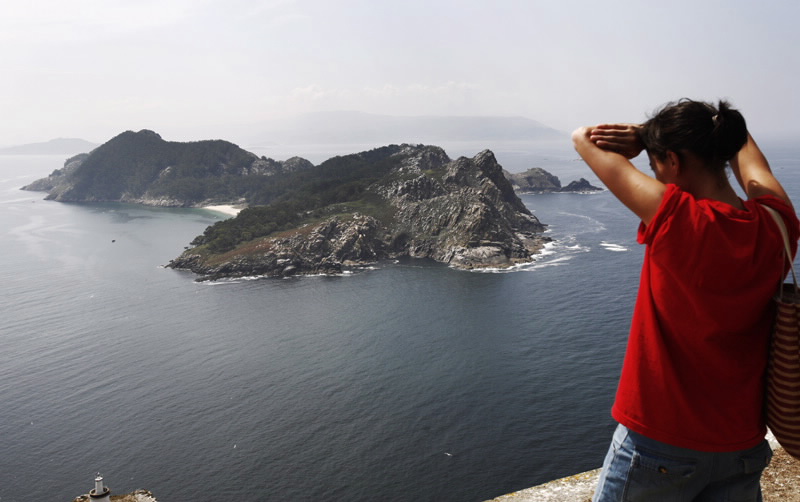
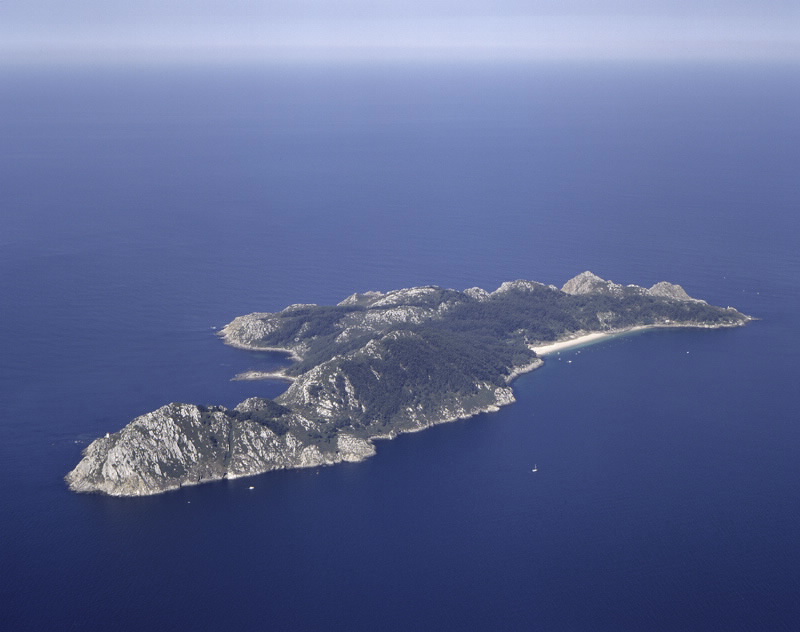
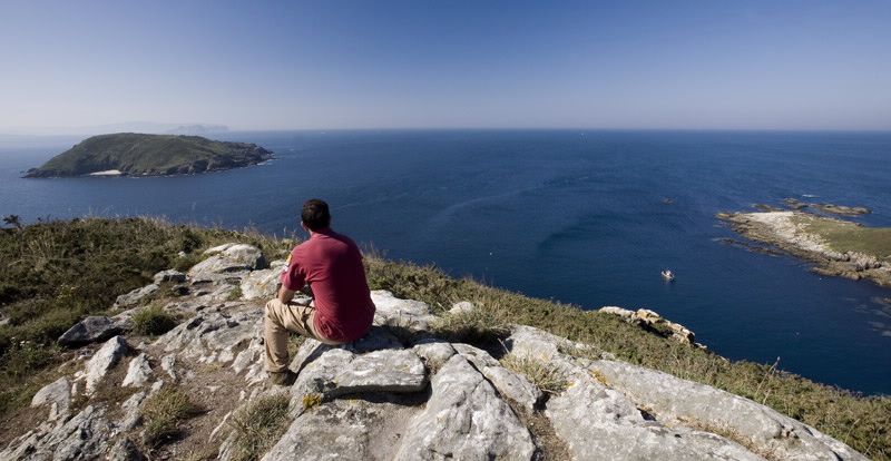
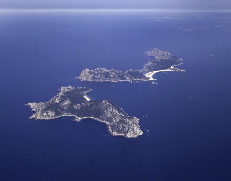
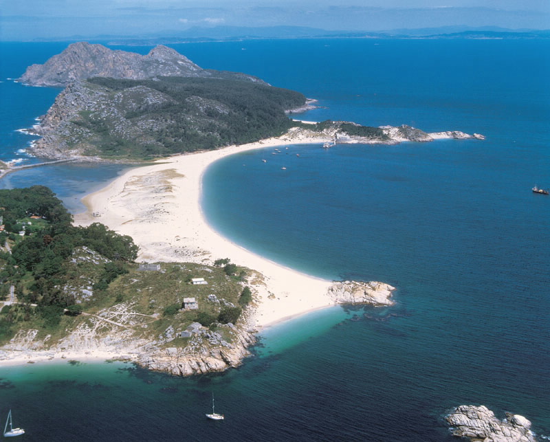
From a boat on the Ría de Vigo one can discern the outline of the three islands that play at being two. They are known as the Cíes because we continue to call them by their Roman nickname of Siccas, the dry islands, although, on their own, each has its own name. That in the north, the Monteagudo, and that in the middle, the Faro (Lighthouse), are joined by the narrow sands of Rodas and a lake which completes this heavenly picture. The island to the south, San Martiño, is separated from the others by a canal called "Freu da Porta". The archipelago also includes a series of small islands that are united beneath the sea in an area of enormous and fragile biodiversity, ranging from the microscopic beauty of the fields of algae to the grandeur of the cetaceans that are frequently to be seen.
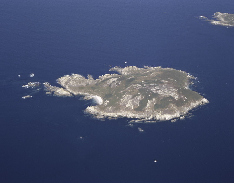
Ons and her sister isle, the Onza or Onceta, and the small island of Las Freitosas, close the Ría de Pontevedra, with a coastline rounded off by sandy beaches. On the other hand, the part which cannot be seen from land is extremely wild and favourable for the formation of undersea caves (furnas) and reefs. The underwater scenery of this part of the ocean is made up of vertical walls, teeming with life thanks to the outcrop of deep water which is rich in nutrients. This is well-known to the people of this island, the only one in the National Park to be inhabited now, who work as fishermen, especially of octopus.
Sálvora, in the extreme west of the Ría de Arousa, with its whole constellation of islands full of legends and sea stories, such as Noro, Vionta and Sagres, is a most complete reserve, both in terms of sea bottom and surface. As with the Cíes and Ons, man has left his mark with buildings for religious (chapels, altars or churches), civil (lighthouses), military (forts) and industrial use. In Sálvora the salting factory was turned into a two-towered pazo (country house) and there is also a fine, traditionallooking village with eight hórreos (raised granaries) and a chapel.
Cortegada and neighbouring Malveiras enjoy the proverbial biological richness of the Ría de Arousa. To observe production activity, the quay and the promenade of Carril with their clams and cockles breeding grounds provide a remarkable insight into shell fishing. The tides are the only borders of the Isla de Cortegada, which looks as if it could be conquered on foot. Sometimes guided visits are organized, which, as well as covering the island’s history, also show the island’s plant treasure, represented by the laurel forest with trees up to twelve metres high, located behind a thick pine grove.
Sailing west is one of the great adventures of the Galician coast. Here can be found the Galician islands, the Cíes, Ons, Sálvora and Cortegada. An archipelago whose waters are turquoise enough and whose sands are white enough to conjure up Caribbean beaches... “until you dip your finger into the water”. This was stated as a point in its favour by The Guardian daily newspaper, which considered the Rodas sands of the Cíes to be the best in the world. Cold waters with the best ocean properties for marine life, and odd stories of sunken ships.
From a boat on the Ría de Vigo one can discern the outline of the three islands that play at being two. They are known as the Cíes because we continue to call them by their Roman nickname of Siccas, the dry islands, although, on their own, each has its own name. That in the north, the Monteagudo, and that in the middle, the Faro (Lighthouse), are joined by the narrow sands of Rodas and a lake which completes this heavenly picture. The island to the south, San Martiño, is separated from the others by a canal called "Freu da Porta". The archipelago also includes a series of small islands that are united beneath the sea in an area of enormous and fragile biodiversity, ranging from the microscopic beauty of the fields of algae to the grandeur of the cetaceans that are frequently to be seen.
Ons and her sister isle, the Onza or Onceta, and the small island of Las Freitosas, close the Ría de Pontevedra, with a coastline rounded off by sandy beaches. On the other hand, the part which cannot be seen from land is extremely wild and favourable for the formation of undersea caves (furnas) and reefs. The underwater scenery of this part of the ocean is made up of vertical walls, teeming with life thanks to the outcrop of deep water which is rich in nutrients. This is well-known to the people of this island, the only one in the National Park to be inhabited now, who work as fishermen, especially of octopus.
Sálvora, in the extreme west of the Ría de Arousa, with its whole constellation of islands full of legends and sea stories, such as Noro, Vionta and Sagres, is a most complete reserve, both in terms of sea bottom and surface. As with the Cíes and Ons, man has left his mark with buildings for religious (chapels, altars or churches), civil (lighthouses), military (forts) and industrial use. In Sálvora the salting factory was turned into a two-towered pazo (country house) and there is also a fine, traditionallooking village with eight hórreos (raised granaries) and a chapel.
Cortegada and neighbouring Malveiras enjoy the proverbial biological richness of the Ría de Arousa. To observe production activity, the quay and the promenade of Carril with their clams and cockles breeding grounds provide a remarkable insight into shell fishing. The tides are the only borders of the Isla de Cortegada, which looks as if it could be conquered on foot. Sometimes guided visits are organized, which, as well as covering the island’s history, also show the island’s plant treasure, represented by the laurel forest with trees up to twelve metres high, located behind a thick pine grove.
Access
Regular passenger transport service by sea to
the Cíes from the port of Vigo, Baiona and
Cangas during the high season. There is the
same service to Ons from Portonovo,
Sanxenxo, Bueu and Marín. Services of a guide
to Cortegada from Carril (Vilagarcía de
Arousa). Sálvora has no transport service by
sea, and access to it is restricted.
The Ways of St. James
Portiguese Route by coast
The Route of the Sea of Arousa and River Ulla
Situation
Off the southern coast of Galicia. They are made up of four archipelagos, Cortegada and Sálvora in the Ría de Arousa, Ons, facing the Ría de Pontevedra and the Cíes, closing the Ría de Vigo. Municipalities of Vilagarcía, Bueu and Vigo in the province of Pontevedra and Ribeira in the province of A Coruña..
Area
8,480 hectares (1,194.80 hectares of land
and 7,138 hectares of sea).
Specifically: Cíes (2,658 hectares of sea and 433
hectares of land), Ons (2,171 hectares of sea
and 470 hectares of land), Sálvora (2,309
hectares of sea and 248 hectares of land) and
Cortegada (147,2 hectares of sea and 43.8 hectares of land).
Services
Accommodation: only on the Cíes and Ons.
Food: only the Cíes and Ons have a restaurant service.
Food: only the Cíes and Ons have a restaurant service.
Without missing
No vehicles are allowed on any of the islands that make up the National Park. Another aspect to bear in mind is litter
control. Visitors should take responsibility for the cans, containers, etc. that they take to the islands.
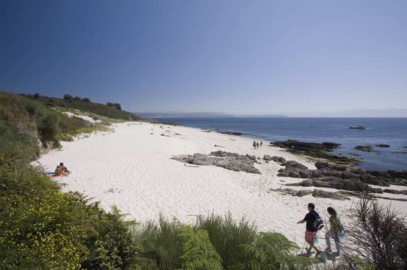
Controlled access to the Cíes of a maximum of 1,800 people daily guarantees peace and quiet. It is easy, from the Rodas jetty, to find the main paths leading to each of the three existing lighthouses. These paths are of medium difficulty, a little demanding on hot days and on some stretches of the ascent. However, the scenery makes it all worthwhile. One of the most recommended routes is the zigzag ascent to Monte Faro, a round trip of 7 km from the jetty and back. On this trip fine birdwatching spots can be found in landscapes like that of A Campá, a real window onto this world carved in stone, where, during the breeding season, a large colony of some 22,000 breeding pairs of yellow-legged seagulls make a deafening racket.
From the jetty of the island of Ons the visitor will find the beach and the village of O Curro, where a long route with several possibilities begins: climb up to the Faro lookout point between the islanders’ buildings, or go north to the solitary and beautiful beach of Melide. Going south, there are different paths leading to the lookout point of Fedorentos, passing O Buraco do Inferno, an underwater cave (furna) in the form of a well where one can hear the roar of the sea coming from the bowels of the earth.
Boarding tickets are issued with the return date and time fixed according to the number of visitors allowed per day on each archipelago. There is no regular transport between one island and another, but tourist cruise ships can be hired to visit all the ecosystems of the estuaries.
Singular nature
All the islands have areas reserved as breeding grounds for sea birds, which the visitor should respect.
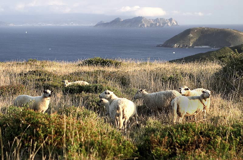
The Park’s most representative natural systems are the coastal area and the Atlantic Continental Platform. Vegetable life is conditioned by the winds laden with saltpetre. The most representative flora is found on cliffs and dunes. Clumps of furze abound, but among the Park rarities are the corema album, Ons broom (Cytisus insularis) and the flowers called sand toadflax (Linaria arenaria), a small annual plant typical of stabilised dunes. Many of the land animals also depend on the sea. Numerous colonies of birds, principally the yellow-legged seagull and the shag. In the sea, there is the possibility of sighting cetaceans like the finback whale which frequents these waters in the summer. The beds of kelp are also of importance in these waters.
The Park’s most representative natural systems are the coastal area and the Atlantic Continental Platform. Vegetable life is conditioned by the winds laden with saltpetre. The most representative flora is found on cliffs and dunes. Clumps of furze abound, but among the Park rarities are the corema album, Ons broom (Cytisus insularis) and the flowers called sand toadflax (Linaria arenaria), a small annual plant typical of stabilised dunes. Many of the land animals also depend on the sea. Numerous colonies of birds, principally the yellow-legged seagull and the shag. In the sea, there is the possibility of sighting cetaceans like the finback whale which frequents these waters in the summer. The beds of kelp are also of importance in these waters.
Information and facilities
Casetas de Información en Cíes, Ons e Cortegada
Centro de Visitantes de Ons e Centro de Información en Cíes
Centro de Visitantes do Parque Nacional
Telephone: +34 886 218 082
Address: Rúa Palma, 4, Vigo
Further features
Bird watching
Special Protection Area
Map


