Turismo de Galicia

-
Things to do
Way of St. James
Nature
Culture and heritage
Beaches and coast
Tourist trails
- Top ten: Ten unrivalled destinations
- The route of the camellia
- Tourist routes
- Pathways for discovering a country
- Walks to fall in love with
- Scenery at the wheel
- EuroVelo Galicia
- Beyond the Sunset
Gastronomy
Health tourism
PROMOTIONS TO ENJOY NOW
Cultural agenda
Will happen... View all
- Places to visit
-
Plan your trip
Build your journey
Practical information


-
A miña viaxe
A MIÑA VIAXE
- Compartir
- Correo
- Imprimir

On the Way of St. James
Description
The Sil treasure
The Lastra mountain range is the natural east of Galicia. Here the holm oak has its own history. It tells about the Mediterranean climate and the limy soil it needs to exist. It is for this reason that it is scarce in the rest of Galicia. It gives its name to the Natural Park, for it seems that in years gone by a massive holm oak acted as a guide to travellers in these parts. It is only a story, but a holm oak like the one in the past can be admired on land near the Covas cemetery, and is recognized as a Singular Tree.
Accompanying the holm oaks we find other Mediterranean species: cork trees, rebolos (oaks with a small trunk), almond trees and olives. There are also chestnut trees, and a mention of them takes us back two thousand years. Then, the Romans transported gold from this region to enrich the Empire. In exchange they left two treasures: their language and the chestnut trees masterly elements of this landscape.
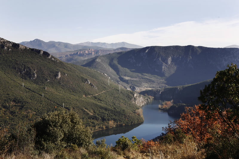
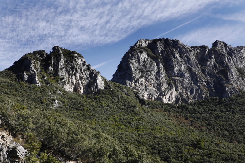
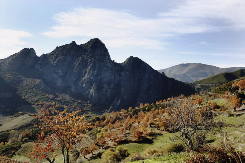
Nobody can remain indifferent to the beauty of the mountain towers of Penedos do Oulego, the shape of the Val do Inferno ravine, the sheer slopes of Pena Falcueira. The Sil divides this mountainous system forming a steep-walled gorge. The Covas straits constitute an aesthetic experience for the travellers who cross the region by train.
And the interior of this land will still surprise us with its palas, a word of pre-Roman origin which means caves. Here are located the biggest network of underground caves in the region and the largest colonies of bats living in the close to two hundred registered fissures and caves, some of which are extremely long, such as the Cova da zorra (600m), or landmarks in Galician potholing, such as the pala of Xilberte, the pala of Pombo, la pala of Trasmonte or la pala of Tralapala.
The Lastra mountain range is the natural east of Galicia. Here the holm oak has its own history. It tells about the Mediterranean climate and the limy soil it needs to exist. It is for this reason that it is scarce in the rest of Galicia. It gives its name to the Natural Park, for it seems that in years gone by a massive holm oak acted as a guide to travellers in these parts. It is only a story, but a holm oak like the one in the past can be admired on land near the Covas cemetery, and is recognized as a Singular Tree.
Accompanying the holm oaks we find other Mediterranean species: cork trees, rebolos (oaks with a small trunk), almond trees and olives. There are also chestnut trees, and a mention of them takes us back two thousand years. Then, the Romans transported gold from this region to enrich the Empire. In exchange they left two treasures: their language and the chestnut trees masterly elements of this landscape.
Nobody can remain indifferent to the beauty of the mountain towers of Penedos do Oulego, the shape of the Val do Inferno ravine, the sheer slopes of Pena Falcueira. The Sil divides this mountainous system forming a steep-walled gorge. The Covas straits constitute an aesthetic experience for the travellers who cross the region by train.
And the interior of this land will still surprise us with its palas, a word of pre-Roman origin which means caves. Here are located the biggest network of underground caves in the region and the largest colonies of bats living in the close to two hundred registered fissures and caves, some of which are extremely long, such as the Cova da zorra (600m), or landmarks in Galician potholing, such as the pala of Xilberte, the pala of Pombo, la pala of Trasmonte or la pala of Tralapala.
Access
The 120 Ponferrada-Ourense road and the
train line cross the Park by Covas. The local
OU-622 road circles the mountain from the N-
120 towards the north. There is also a turnoff
towards Biobra.
The Ways of St. James
The Winter Camino
Situation
In the Rubiá municipality, belonging to the
Ourense region of Valdeorras, bordering El
Bierzo (León).
Area
3,151.67 hectares.
Services
In the area, outside the Park.
Without missing
The journey itself, along the local roads that join the small villages in the interior and along the borders, shows the beauty
of the landscape. The Park has areas of restricted access. It is necessary to contact potholing associations in order to be
able to explore the caves.
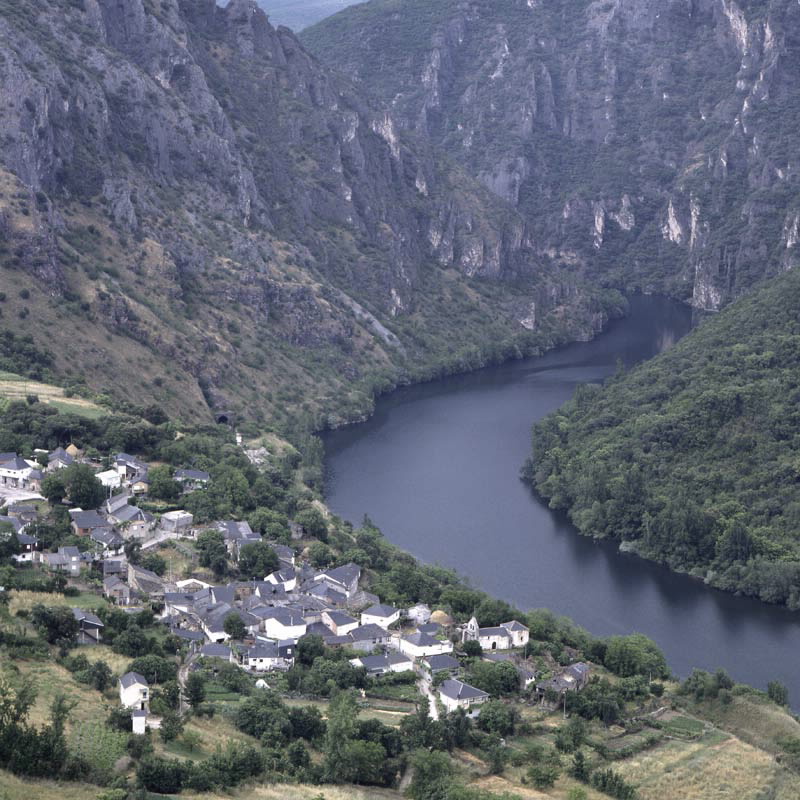
Covas and Biobra, where the Visitors’ Centre is located, are both of special interest in this area. The route between
Vilardesilva and Covas runs along the right bank of the Sil, taking us to the river gorge with incredible narrow passes that
dam up the waters and act as hunting places for birds of prey.
On the other hand, we can go to the Penedos of Oulego along a very demanding path which uses forest trails to show us
hidden natural scenic paradises which are the best kept secret of the hard eastern mountains.
Singular nature
There are outstanding holm oak woods, chestnut groves and Mediterranean scrubland with special characteristics,
such as fields of wild thyme. Flowering plants endemic to limy soil and other rare plants like the more than 25 species
or orchids. The gorges and sheer river passes are the habitats of birds of prey and other birds which make the Park
an interesting ornithological refuge. It has the largest concentration of nesting birds in Galicia, and large colonies of
bats live in the caves.
Information and facilities
Oficina del Parque Natural, Centro de Visitantes
Telephone: +34 988 324 319
Address: Biobra
Further features
Bird watching
Special Protection Area
Download the coordinates for this resource...
Map


