Turismo de Galicia

-
Things to do
Way of St. James
Nature
Culture and heritage
Beaches and coast
Tourist trails
- Top ten: Ten unrivalled destinations
- The route of the camellia
- Tourist routes
- Pathways for discovering a country
- Walks to fall in love with
- Scenery at the wheel
- EuroVelo Galicia
- Beyond the Sunset
Gastronomy
Health tourism
PROMOTIONS TO ENJOY NOW
Cultural agenda
Will happen... View all
- Places to visit
-
Plan your trip
Build your journey
Practical information


- Start
- Things to do
-
Scenery at the wheel
- Way of St. James
- Galician Woodlands
- Experiencies in the midst of nature
- Magical Shrines
- Lighthouses and Wild Beaches
- Galicia Birding
- MTB Centres
- EuroVelo Galicia
- Hidden Heritage
- Marine Tourism
- Galicia Water Society
- Tourist routes
- The route of the camellia
- Scenery at the wheel
- Top ten: Ten unrivalled destinations
- Strolling Through Vineyards
- Pathways for discovering a country
- Walks to fall in love with
- Beyond the Sunset
- Galician springs
- Promotions to enjoy
- Cultural agenda
- 25 unusual routes through the best landscapes in Galicia
- Valleys, rivers and mountains
-
From Aquis Querquennis to A Portela do Home
- From Fonsagrada to Negueira de Muñiz
- From Navia de Suarna to As Pontes de Gatín
- From Pedrafita do Cebreiro to Samos
- From A Cruz do Incio to the viewpoint at A Pena do Teso Grande
- From Chantada to Os Peares
- From Monforte de Lemos to Santo Estevo de Ribas de Sil
- From A Veiga to the Penedos de Oulego
- From A Pobra de Trives to As Ermidas
- From Montederramo to Manzaneda
- From A Gudiña to Pradoalbar
- From Aquis Querquennis to A Portela do Home
- From Ourense to Ribadavia
- From Avión to the Tres Rías lookout point
- From Aciveiro to Carboeiro
-
A miña viaxe
A MIÑA VIAXE
- Compartir
- Correo
- Imprimir
Valleys, Rivers and mountains
From Aquis Querquennis to A Portela do Home... Roman remains in A Baixa Limiaplaced so high up,
among gorse and genista
with oaks around
Cantigueiro popular da Baixa Limia, Xaquín Lorenzo
The Roman heritage of A Baixa Limia is visible all around in A Baixa Limia, alongside its outstanding natural attractions and magnificent landscape. This pleasant route through the Limia valley visits a series of charming locations, allowing travellers to rediscover the historical routes through the Serra do Xurés, leading to Portugal.
 Aquis querquennis
A Baixa Limia is a county with a character of its own. The River Limia valley has been a through route since ancient times, its importance for communications being confirmed by many remains that can be seen today.
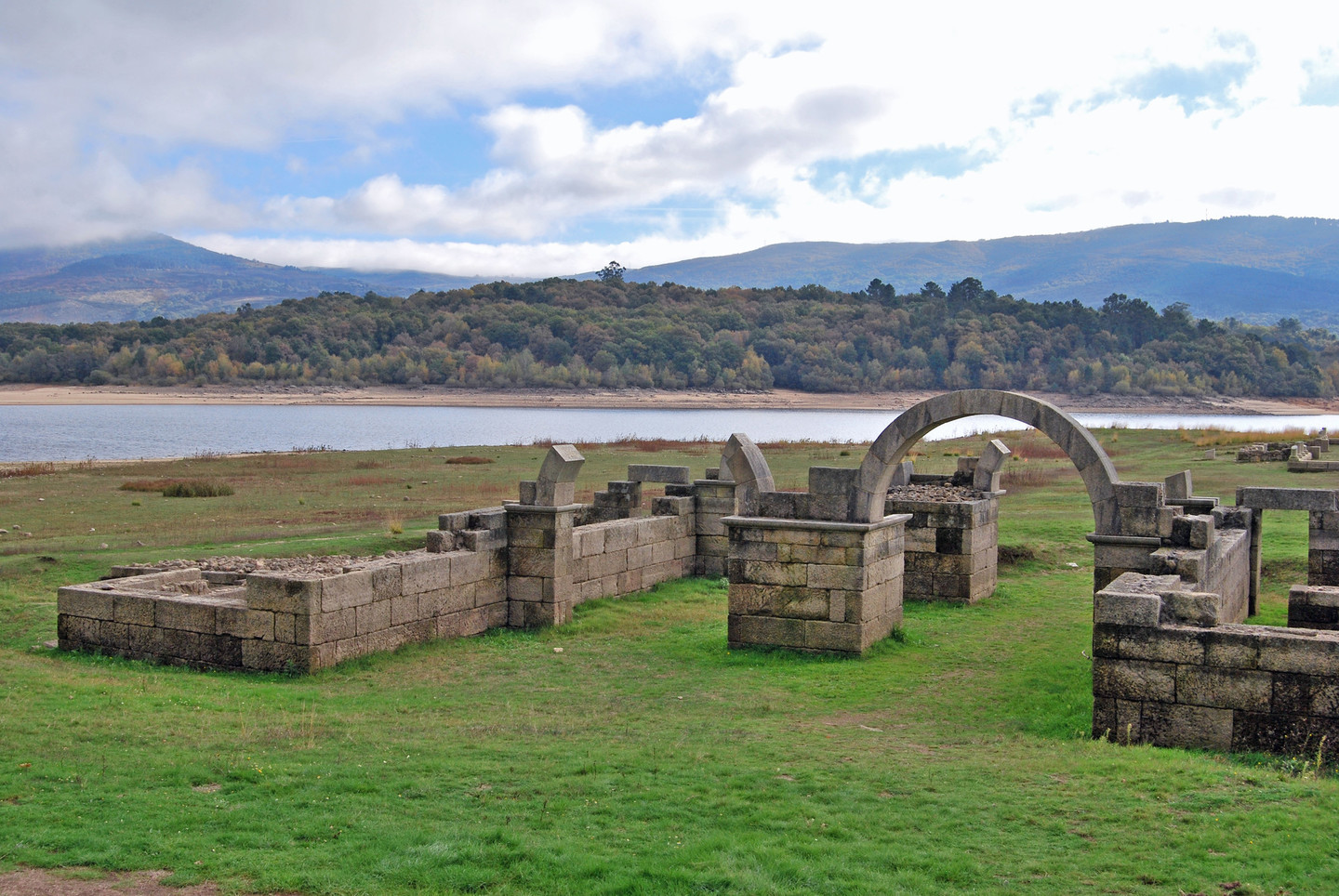
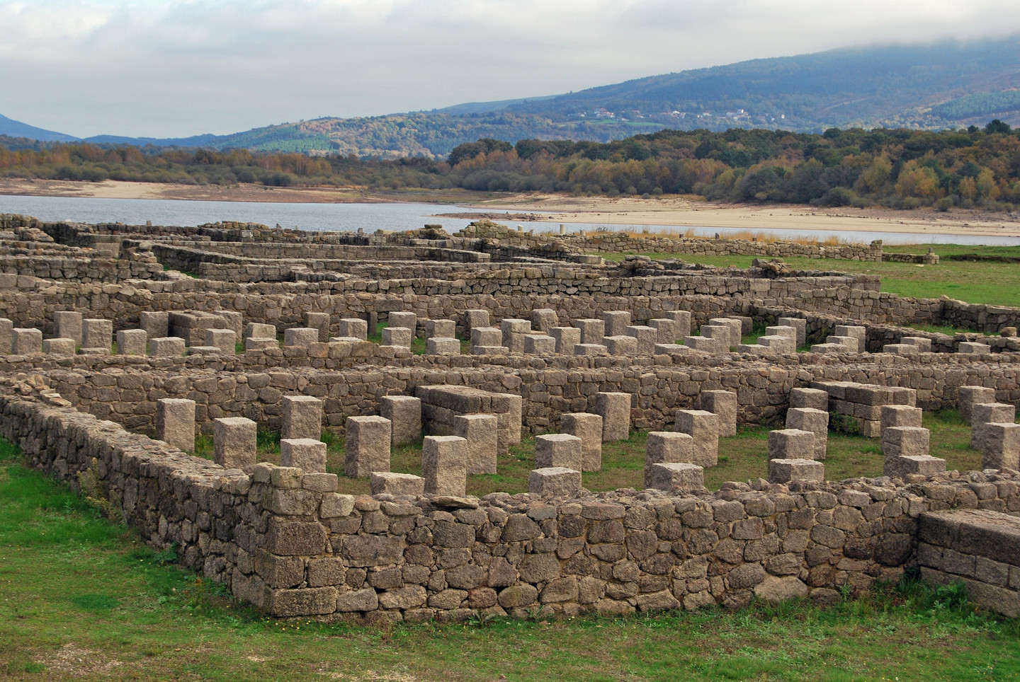
Aquis Querquennis is an archaeological site that illustrates the importance of the area’s Roman heritage. This rectangular military camp with thick walls is located at Porto Quintela on the banks of the Limia. Two of the gates have been restored as has the Principia, or camp headquarters.
The camp contains a series of walls, interior tracks and drainage channels, although part of the site was covered when the As Conchas reservoir was built in 1949. Excavations indicate that it was occupied for approximately fifty years (79 AD to 120 AD). Its location on the Via Nova would seem to indicate that it acted as a base for operations on this major artery. The complex also includes a mansio, a construction built as a stopping point on the route, and hot baths. Entry to the site is free and there is a modern interpretation centre providing additional information about its history.
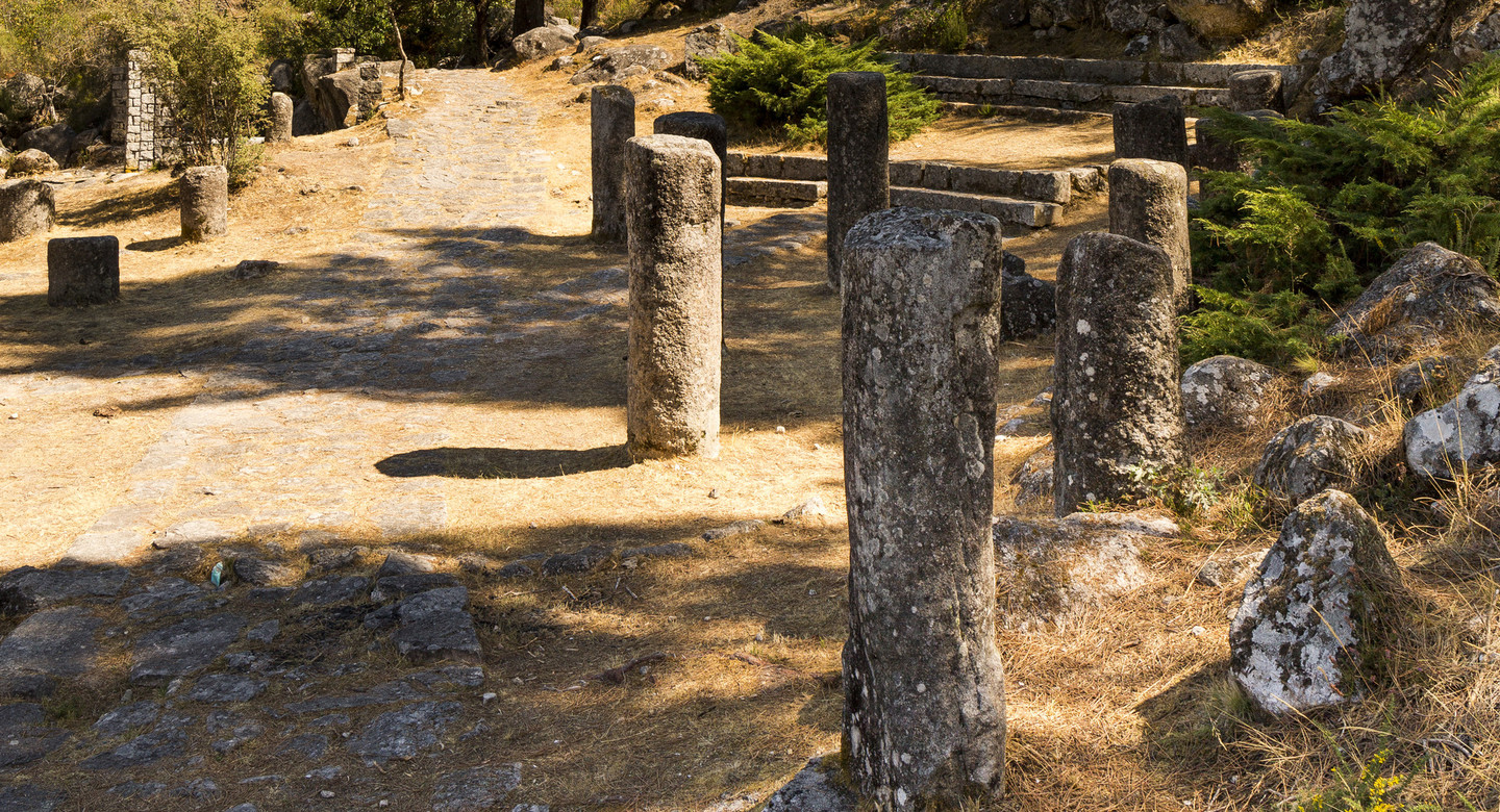
Road XVIII on the Antonine Itinerary, known as the Via Nova, was a Roman road built in the first century AD, linking Bracara Augusta (Braga in Portugal) and Asturica Augusta (Astorga in Castilla y León). In A Baixa Limia the Via Nova followed the Limia and Caldo river valleys, where it ran between the Serra do Xurés and Celanova.
 Lindoso reservoir
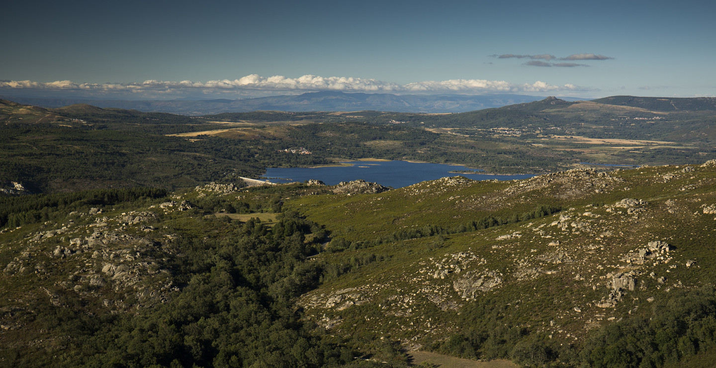
This route runs mainly along the old Via Nova. From Aquis Querquennis the course of the River Limia leads to the As Conchas reservoir. A short distance downstream lies the Lindoso reservoir in Portugal. The route continues across a modern bridge to Lobios, a significant municipality in the area.
 Thermal baths in the River Caldo
The peaceful road then leads to Os Baños, a remarkable complex with hot springs on the banks of the River Caldo, used by the Romans for contrasting hot and cold baths. The traditional villages with their carefully cultivated terraces gradually give way to a mountain landscape dominated by pine trees and rocky outcrops. Small streams, known as corgas in this region, flow from the hills and rush down the steep slopes. A Corga da Fecha is the best known.
In the heart of the Serra do Xurés, after a small bridge over the River Caldo, the route comes to a series of Roman milestones, and a reconstructed stretch of the Via Nova which is a pleasure to walk along.
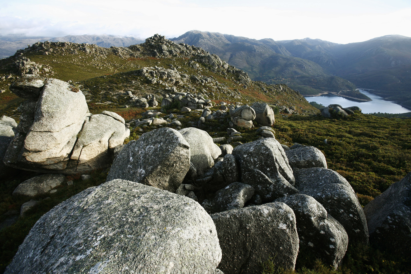
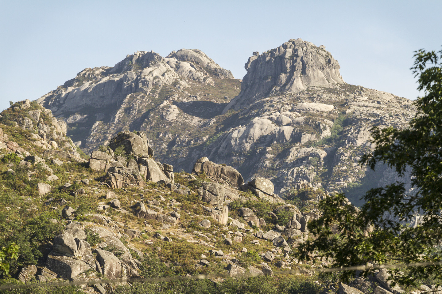
Baixa Limia-Serra do Xurés is a protected natural space, declared a Natural Park in 1993. Located in the south-western corner of Galicia, it comprises a series of mountain ranges (Xurés, Peneda, Laboreiro, Quinxo, etc.) and the River Limia valley, an ecological corridor for the area.
The landscape is dominated by mountains, with many round boulders and pinnacles at the top of the worn peaks, none of which exceed 1,500 metres.
The combination of the area’s rich historical and ethnographical heritage with its natural attractions creates a space of great cultural and aesthetic interest.
Baixa Limia-Serra do Xurés, the largest natural park in Galicia, and Peneda- Gerês, Portugal’s only national park, form an attractive cross-border protected space.
 Natural park Baixa Limia-Serra do Xures
A Portela do Home marks the end of the route, where the road enters Portugal. At 822 metres this iconic mountain pass is the most southerly point in Galicia. On both sides of the border there are areas of great natural beauty.
Don't Miss
 The lookout point at A Corga da Fecha
The corgas are mountain streams. In A Baixa Limia the term is very common, as there are numerous such streams flowing down the granite walls of the Sierra de O Xurés.
The Fecha is a small tributary of the River Caldo. “Fecha” means “stream” so that Corga da Fecha would mean something like “the course of the stream”. Other corgas such as the Carballón, Curro and Revolta flow into it. The volume of water in the streams varies according to the season, winter and spring being the periods when the flow is greatest.
With a drop of over two hundred metres, the Corga da Fecha is an impressive sight and one of Galicia’s highest waterfalls. The water cascades over a series of rock shelves, falling from one level to the next.
On the road leading up to A Portela do Home there is a lookout point that allows the Corga da Fecha to be seen from a distance, so that it can be fully appreciated.
