Turismo de Galicia

-
Things to do
Way of St. James
Nature
Culture and heritage
Beaches and coast
Tourist trails
- Top ten: Ten unrivalled destinations
- The route of the camellia
- Tourist routes
- Pathways for discovering a country
- Walks to fall in love with
- Scenery at the wheel
- EuroVelo Galicia
- Beyond the Sunset
Gastronomy
Health tourism
PROMOTIONS TO ENJOY NOW
Cultural agenda
Will happen... View all
- Places to visit
-
Plan your trip
Build your journey
Practical information


- Start
- Things to do
-
Scenery at the wheel
- Way of St. James
- Galician Woodlands
- Experiencies in the midst of nature
- Magical Shrines
- Lighthouses and Wild Beaches
- Galicia Birding
- MTB Centres
- EuroVelo Galicia
- Hidden Heritage
- Marine Tourism
- Galicia Water Society
- Tourist routes
- The route of the camellia
- Scenery at the wheel
- Top ten: Ten unrivalled destinations
- Strolling Through Vineyards
- Pathways for discovering a country
- Walks to fall in love with
- Beyond the Sunset
- Galician springs
- Promotions to enjoy
- Cultural agenda
- 25 unusual routes through the best landscapes in Galicia
- Endless sea
-
From Baiona to Santa Trega
- From Ribadeo to Pico da Frouxeira
- From O Porto de Espasante to the Estaca de Bares lighthouse
- From Cedeira to Cape Ortegal
- From the castle of A Palma to the castle of A Nogueirosa
- From the Laxe lighthouse to O Roncudo point
- Camariñas circular tour
- From the Fisterra lighthouse to the lookout point at O Ézaro
- From Corrubedo lighthouse to Monte Enxa
- From Cape Udra to Cape Home
- From Monte Cepudo to Monte Aloia
- From Baiona to Santa Trega
-
A miña viaxe
A MIÑA VIAXE
- Compartir
- Correo
- Imprimir
ENDLESS SEA
From Baiona to Santa Trega...the south coast
North-east out there.
Popular saying
The route along the southern coast of Galicia follows a unique shoreline, without the rías, coves and inlets typical of the region. The road linking Baiona and A Guarda goes through one of the most beautiful landscapes on the Galician coast: a long straight line bordering the sea, running from north to south alongside the amazing A Groba mountain range.
 Baiona and The Monterreal fortress
Baiona is the starting point for our journey. A seafaring town, popular with tourists, it was established long ago taking advantage of the site's good climate and sheltered position in a small inlet. With its carefully conserved sea front, its old centre was declared a Historical and Artistic Site in 1993.
The Monterreal fortress is the town's most important historic building. Its location on Monte Boi, a small peninsula beside the harbour, defines the Baiona shoreline. Its strategic position was historically important, and it was a walled precinct from the second century BC. The Catholic Monarchs granted the precinct a charter of settlement, inaugurating a period of trading splendour, but its importance gradually declined until it was abandoned in the nineteenth century.
The Monterreal site contains various buildings and other remains, including the gates leading to the fortifications and the towers (Porta do Sol, Príncipe, Tenaza and Reloxo), while the nineteenth-century Pazo de Elduayen was extensively refurbished in the 1960s to house the present Parador de Turismo.
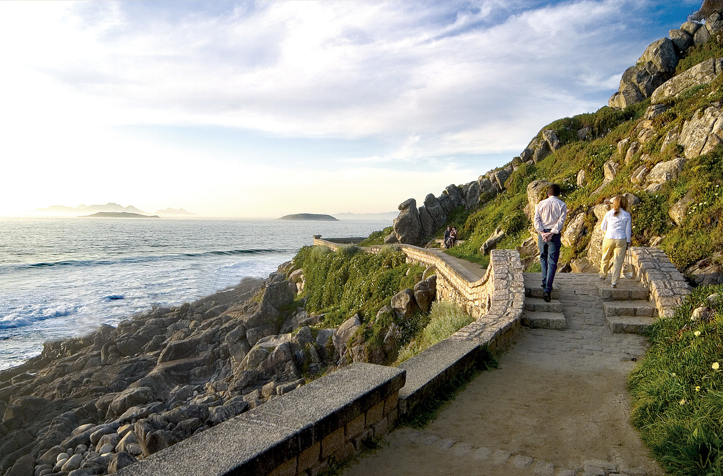
 View of Cape Silleiro
After leaving Baiona our first stop is Cape Silleiro, where the shoreline turns to run from north to south. The area contains numerous features of interest: artillery batteries, viewpoints and lighthouses.
The old Silleiro lighthouse (1866), close to the sea and almost at sea level, was replaced by a new octagonal lighthouse with red and white stripes in 1924. The cape area is spectacular: open sea, views of the Cíes islands and crags that appear to emerge from the sea and continue to the top of the hills.
 A Groba range
The long straight section of the south coast begins at Silleiro, keeping the sea to the right and the A Groba range steadily rising to the left, reaching 654 metres at Alto da Groba. The route provides a succession of delightful views of the green hills and the blue sea. At times it is not clear where the land ends and the sea begins, with water blowing onto the road on windy days.
Between Mougás and Oia the mountains give way to the sea, in an open coastal area where crops are grown on small, irregularly shaped plots bordered by stones, with occasional terraces to make better use of the slopes.
The route follows the A Groba range along the south coast from Cape Silleiro to the area near A Guarda. The granite-based mountains have crags and scrubland at the top and extensive pine woods on their lower slopes.
Forestry and livestock both play an important role in A Groba and it is not unusual to find cattle grazing loose in the hills or wandering along the forest trails. In summer they are often rounded up. The curros are enclosures used in an ancient rite known as the Rapa das Bestas, an impressive feat of strength when the wild horses are gathered in to be marked and have their manes trimmed.
This range is most impressive on its western side, which drops steeply, creating sweeping views over the sea.
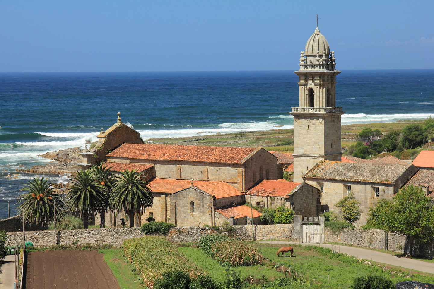 The majestic Santa María monastery
Oia is a small village in a corner of the coastline. It follows the sea front and has narrow streets and a harbour immediately beside the majestic Santa María monastery. In the late afternoon the sun shines directly onto the façade giving it a wonderful warm glow.
 View of A Guarda
A Guarda is in Galicia’s furthest south-west corner. A village of bright colours with close links to the sea, the houses in the harbour retain the traditional structure but their height has increased over the years. Their spirit is unchanged and memories of the village’s seafaring past are very much alive. There is a promenade along the sea front and a strong harbour wall, although this may seem insufficient when the Atlantic is at its fiercest. The waves crash against the wall and A Guarda is sprayed with sea water.
 Mount and Santa Trega fortified settlement
Santa Trega is a mythical hill.
Overlooking A Guarda from a height of more than 340 metres, it rises suddenly, standing alone where the Miño flows into the Atlantic. This strategic location has been occupied since ancient times, with many archaeological remains showing how important it was. These include rock carvings, the hill fort, one of the most visited in Galicia, and the Santa Trega hermitage, which has given the hill its name.
The fortified town is a large archaeological site, an example of the Castro culture, which reached its peak in the first century BC. The large number of buildings reveals how substantial the settlement was, thanks to its strategic position and economic importance. Circular constructions predominate but the influence of Roman building styles can be seen in other, rectangular structures and in the defensive walls. The site was declared a Historical and Artistic Monument in 1931 and it is also a Cultural Heritage Site.
The views at the top of the hill provide a 360o panoramic vista: A Guarda and the A Groba range to the north, Baixo Miño to the east, Portugal to the south and the vast Atlantic to the west.
The ancient stones of the fortified settlement reflect the play of light and colour of the sunsets over Santa Trega.
From this superb vantage point, with the River Miño flowing into the immensity of the Atlantic, on the border between two countries, and a wealth of views from the top of the hill, the twilight moments at the end of the day, when all shapes are seen as shadows, are a sublime experience.
Don't Miss
 The Santa María de Oia monastery
The origins of the Santa María de Oia monastery are uncertain. It may have been founded by Saint Martin, Christian evangelist and bishop of Braga, who is said to have converted the Suevi to Christianity in the sixth century.
In the twelfth century the Benedictine monastery was transferred to the Cistercians. Located in a remote and relatively undeveloped region, the monastery’s activity led to changes in the local landscape and economy, with the introduction of new crops and livestock (vines and the Baixo Miño horses are attributed to the order).
Architecturally, the mediaeval church is the outstanding feature of the monastery. In a unique setting, blending perfectly into the coastal landscape, unusually for a Cistercian monastery the façade looks towards the sea.
The remains of an old quay are evidence of the monks’ connections with seafaring and fishing. Declared a National Monument (currently a Cultural Heritage Site) in 1931, it awaits the support needed to restore it to its former beauty.
