What could be considered the last stretch of Costa da Morte together with the estuary of Muros and Noia, delights all five senses with amazing long beaches surrounded by intense coastal nature.

Carnota, at over 7 km, is considered the longest beach in Galicia.

For many of you this beach will no doubt look familiar, as it was where Alejandro Amenábar filmed his well-known film The Sea Inside.

Day 1

Whichever way you choose to come to Carnota, you will never forget the first time you see its beaches. If the starting point is Cee, the impressive 627 metres of Monte Pindo will accompany you all the way until you reach your destination; and if you choose the Negreira road, you will enjoy an astonishing bird’s-eye view of the whole coast line. Caldebarcos Beach is the northernmost beach in the municipality of Carnota. It is just over 1.5 km long, and just like the next beaches we will visit, the sand is white and could be confused with that of the warmest areas on the planet.

Apart from its surroundings, the fishermen’s huts stand out – they have just been restored and are related to the fishing and shellfish activity of the area; and the natural environment of Berberecheira, where the shellfish gatherers work on foot. Windy and with frequent coastal breezes, Caldebarcos is ideal for practising water sports such as surfing and windsurfing, apart from being a regular mooring spot for leisure yachts. A stroll around the area is a good way of remembering that in the depths of the sea of Caldebarcos lie the wrecks of various ships from the Spanish Armada, when they were on their way to conquer England in 1596. If it is lunchtime, trying an exquisite dish of octopus with clams in one of the restaurants in the area could also be a unique experience.

We follow this gentle coast line towards Carnota beach, which was included as one of the hundred best beaches in the world by German magazine Traum Strände. From the road, it looks immense. At over 7 km long, it is considered the longest beach in Galicia. At low tide, it is more than a thousand metres wide at some points. In the broad area of marshland and dunes there is a great variety of migratory birds and native flora. In fact, this is one of the few places in Galicia where the Kentish Plover nests. The large arrow of sand in the mouth of the River Valdebois, better known as the River Mouth, gave rise to one of the natural spaces of greatest ecological and landscape interest in Galicia: the wetlands of Caldebarcos and Carnota Beach.

If you are lucky, you will be able to see one of these species while you cross the large wooden walkway that seems to float over this wetland until it flows into the coast line. In this inlet between the Puntas de Caldebarcos and Sargas, the water is turquoise, the sand is fine and white, the sun is intense; there are very few people in the first hours of the day and the sight of a completely calm sea creates a magical and evocative sensation. Do not miss a walk along the sea shore, enjoying this heavenly atmosphere while your footprints keep disappearing as the waves come in. In the background, at the other end of the estuary of Corcubión, the mythical Cape Fisterra gazes at you from afar. Bid farewell to the place with a last glance; if you are lucky, you might find a bottle with a message inside...

Also in the area around Carnota, but at the limit with Muros, we come to Lariño beach. The beach is divided into two well-defined parts. On the one hand, a tongue of sand about two kilometres long, and on the other, a series of creeks located on a base of ground that was a mute witness to the level of the sea in previous periods. In the one known as Punta da Ínsua, the geographical point that helps fix the entry in the arc of Fisterra and the estuary of Corcubión, you will find the Lighthouse of Lariño, dating from the 1920’s, beside the remains of an old windmill. Near here the Spanish destroyer Ariete sank in 1966; the Spanish Fleet granted the title of “Most humanitarian” to the Town Council of Carnota for helping to save the ship’s crew.

Ancoradoiro opens the prolific section of beaches in the municipality of Muros, separated from our previous stop by nothing more than a pinewood. Once again, you will see how surf and windsurf boards are driven by the north winds; as are those who wish to take a stroll up to Area Maior beach and Lagoa de Louro along a narrow path amidst dunes and saw grass. While here, you will have the sensation that Monte Louro is watching you like a stone sentry. At its side, the dunes make up a natural barrier with the fresh water lagoon of Xarfas and the solitary beaches of Area Maior. The legend tells how a village disappeared in the wetlands and that Monte Louro was a sun temple in antiquity, like that on Cape Fisterra.

Continuing towards the town of Muros, you will come across a diversion that takes you to the lighthouse of Louro, located at 241 meters above sea level. From there, you will enjoy pleasant views of the entry into the estuary of Muros and Noia, the Sierra de Barbanza and even Corrubedo.

As it is nearby, you will be able to visit the petroglyph of Laxe das Rodas. Here you will see rock engravings carved in granite that several experts relate to the cult to the sun, while others interpret them as a work almanac, an altar to obtain good harvests, death or fertility.

Louro is a small summer locality with a long-standing tourist tradition. You will find many of the cuisine delights of the estuary and the sea in the taverns and restaurants to flood your palate with the intense flavours and to complete the experiences of this first day.

Day 2

Leave the visit to the town of Porto do Son for your second day. You can make the most of it to have a coffee near the port or even to take a short walk: the salt fragrance, vessels that come in after a long day’s work, others that sail out or sailors repairing their nets are the best proof of the importance of seafaring for this attractive fishing village.

We continue the journey towards the beach and the Hill Fort of Baroña beach and the Hill Fort of Baroña. Nature offers us an advantage here: these waters are perfect for obtaining a good tan due to the high concentration of iodine. The beach of Hill Fort of Baroña is sheltered from the winds by its good location between two stony hills about 50 metres high. Baroña is one of the best known hill forts in Galicia. This prehistoric settlement has almost twenty buildings and a splendid wall that defended its inhabitants. It dates to around the first centuries B.C. and A.D.

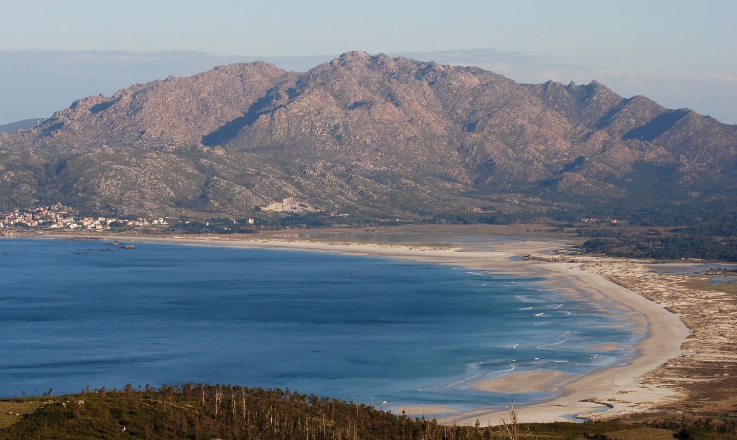
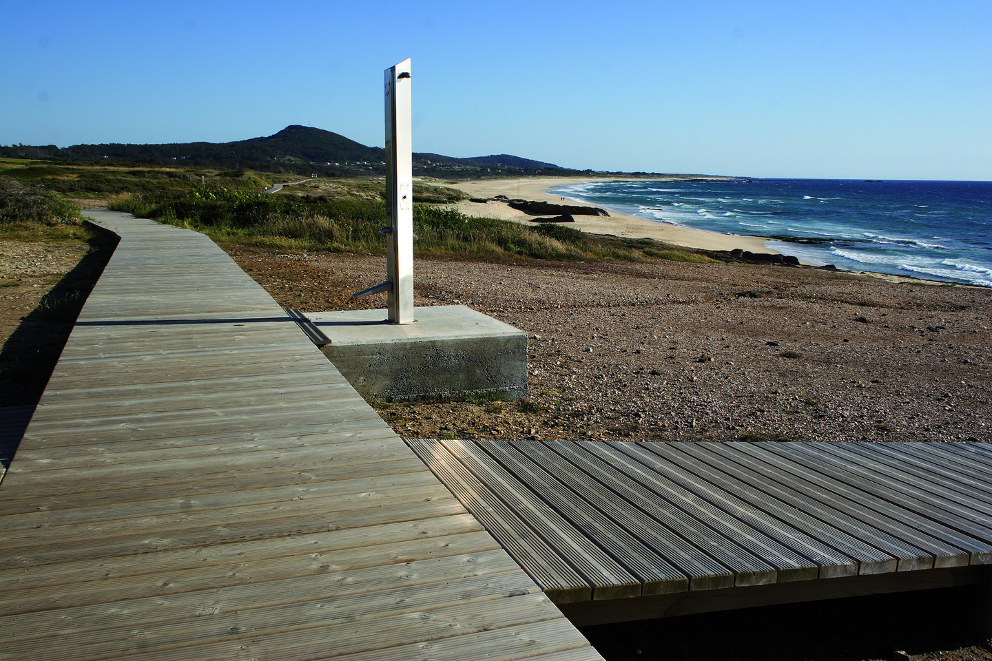
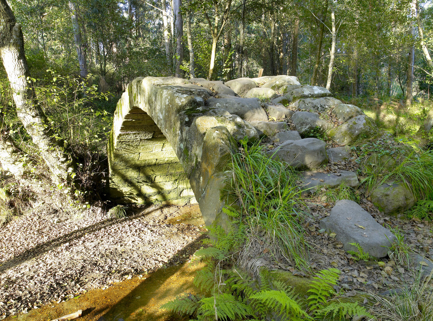
The route continues on towards Furnas beach, but it is worth stopping to visit the bridge over the River Sieira, close to the waterfalls of the same name, taking us back to medieval times. The bridge is a slightly pointed stone arch, part of an old King’s Highway under the shade of a riverbank forest. The current leads to the nearby beach of the same name, forming a lagoon that allows you to bathe in fresh water right by the sea. Its almost white unspoilt sand and gentle waves are joined to Furnas beach by a wooden walkway. For many of you this beach will no doubt look familiar, as it was where Alejandro Amenábar filmed his well-known film The Sea Inside. River Sieira-As Furnas are the last beaches that we will visit in the town of Porto do Son. They are also a regular destination for the holiday makers who walk along the beach, just less than one kilometre long, with a surface of sand and rocks, as if it were a promenade.

Arriba