mailto:?subject=Versendung eines Inhalts von Galizien Tourismus: COSTA ÁRTABRA&body=Ich empfehle Ihnen, die aus dem Portal von Galizien Tourismu auf der Seite https://www.turismo.gal/recurso/-/detalle/16866/costa-artabra?tp=1%26ctre=9 entnommene Info COSTA ÁRTABRA zu lesen
COSTA ÁRTABRA

Datos do recursos turístico
Standort
Cariño | Cedeira | Ferrol | Narón | Ortigueira | Valdoviño
Beschreibung
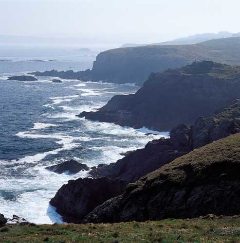
Der "Magnus Portus Artabrorum" ist der Name, mit dem die Römer einen Ort des nordwestlichen Landstriches der galicischen Küste, zwischen den Rias Ares und Ortigueira, bezeichnet haben und dessen genauen Lage unbekannt ist. Hundert Kilometer Küstenlinie mit den prächtigsten Meer- Land Zusammenstellungen des Atlantischen Ozeans: drei Rias, weite Sandflächen mit vielen Wellen und Dünen, Küstenlagunen und die höchsten Klippen Europas. Dieses Gebiet ist geologisch hochinteressant und sein internationaler Ruhm lässt sich von selbst in der reichen Vielfalt von Felsen rechtfertigen, in denen sich diese wahren Sierras, wie die von A Capelada, bestärken und sich über dem Ozean abzeichnen. An seinem Abhang befindet sich einer der ältesten Wallfahrtsorte, Santo André de Teixido, wo ein volkstümliches Sprichwort klar besagt „vai de morto quen non foi de vivo“ (wer nicht lebend kommt, kommt als Toter). Es ist wahrhaftig eines der magischen Mekkas von Galicien, die mit seinen Votivgaben aus Brosamen und seiner „capela dos ofrecidos“ (Kapelle der Darbringer) hervor sticht.
In diesem Küstenstreifen gibt es außerdem zahlreiche und bescheidene Leuchttürme. Die Landwege zu ihnen sind durchaus interessant und, von Angesicht zu Angesicht mit dem Unendlichen, stecken sie den Touristen mit ihrer Bühnenemotion an. In der Ria von Ferrol, Kap Prioriño und, ein bisschen nördlicher, sein Bruder Kap Prior sind zwei von diesen kleinen einsamen Lichter. Dazwischen befindet sich der Strand Doniños mit der ersten, typischen Küstenlagune. Sie ist tiefer als die der anderen Sandflächen von San Xurxo oder Pantin, die auch Seeräume mit Süßwasser besitzen. Dennoch ist die größte Lagune die von A Frouxeira, die Einzige mit Salzwasser. Sie befindet sich am Strand Valdoviño und ist ein geschütztes Feuchtgebiet, das ein bedeutender Zufluchtsort für Vögel ist.
Zugang
Die Jakobswege
Situation
Fläche
Servizos
Essen: Ja.
Ohne Verlust
Zwischen diesem Sanktuar San André de Teixido und Cariño verläuft durch die Sierra A Capelada eine der abenteuerlichsten Straßen Galiciens. Hier werden Sie, unter Vorsichtsmaßnahmen, Pferde und Kühe sehen, die frei auf Weiden zwischen Windkraftgeneratoren auf Anhöhen zwischen 500 und 600 m, wortwörtlich, über dem Meeresspiegel getrieben werden. Die Klippen in A Vixía de Herbeira (613 m) weisen den Rekord der Höchsten des Alten Kontinenten auf.
Unser Besuch würde trotz allem unvollkommen sein, wenn wir ihn nicht beim Leuchtturm des Kaps Ortegal beenden. Von hier aus kann man Os Aguillóns bewundern, scharfe Felsen, die sich aus einem immer wütigen Meer erheben.
Weitere Merkmale
Vielleicht interessiert Sie auch...
-

COSTA DE DEXO
ZEC — Natura-2000-Netzwerk


