


mailto:?subject=Envoi de contenu de Tourisme Galice : CANÓN DO SIL (A RIBEIRA SACRA)&body=Je vous recommande de lire les informations CANÓN DO SIL (A RIBEIRA SACRA) extraites du portail de Tourisme Galice https://www.turismo.gal/recurso/-/detalle/16954/canon-do-sil-a-ribeira-sacra-?ctre=9%26tp=1
CANÓN DO SIL (A RIBEIRA SACRA)

Datos do recursos turístico
Localisation
A Pobra do Brollón | Carballedo | Chantada | Monforte de Lemos | O Saviñao | Pantón | Ribas de Sil | Sober
OurenseA Peroxa | A Teixeira | Montederramo | Nogueira de Ramuín | O Castro de Caldelas | Parada de Sil
Description
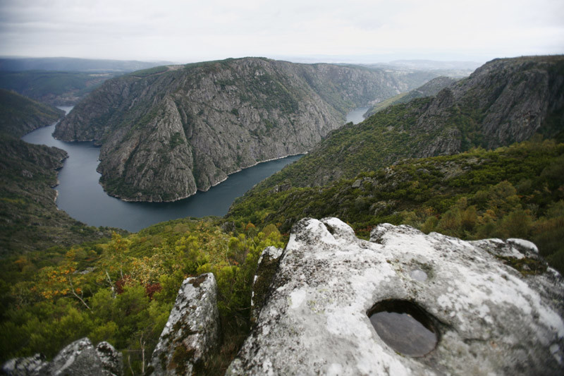
L'érosion fluviale du Sil a creusé sans discontinuer la profonde fente jusqu'à son embouchure sur la rive gauche du Miño. C'est sur ces parois impossibles qu'ont cherché refuge des moines et ermites et, armés de la même patience séculaire, les ont peu à peu peuplées de monastères. Jusqu'à une douzaine de monastères, romans et bénédictins pour la plupart qui lui donnèrent son nom, attesté par des documents dès le moyen-âge, de Rivoyra Sacrata.
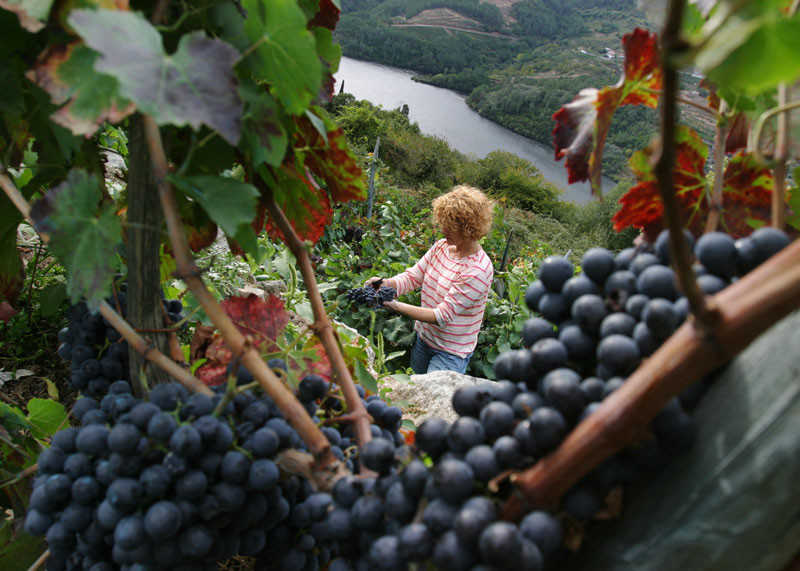
Bien qu'il s'agisse de l'un des meilleurs espaces naturels définis par les deux grands cours d'eau, personne ne sait où commence et finit exactement la Ribeira Sacra. Il se peut que ses véritables limites soient définies par la présence des vignobles sur ses coteaux ensoleillés. C'est de là que venaient les vins d'Amandi déjà renommés sous l'empire romain et qui comptent aujourd'hui une Denominación de Origen (AOC) qui les protège.
Les monastères furent excloîtrés et les eaux furent retenues par des barrages successifs, mais la force du paysage continue de vibrer dans chaque récolte de ses fruits. Il suffit d'admirer les pénibles vendanges sur les fortes pentes que l'on ne peut cultiver qu'en terrasses pour appréhender le meilleur exemple de paysage humanisé sans hâte.
La nature la plus agreste trouve sa place sur les affleurements granitiques revêtus de buissons et de forêts de châtaigniers et de chênes. Les conditions climatiques très spéciales des zones les plus protégées favorisent la présence d'espèces méditerranéennes comme les chênes-lièges et les arbousiers. L'ensemble de hauts rochers dans les gorges ont été cités à plusieurs reprises comme l'un des derniers refuges des oiseaux rapaces les plus menacés.
Accès
Chemins de Saint Jacques
Situation
Surface
Services
Restauration : Oui.
Sans perte
Les monastères les plus liés au cours du Sil sont ceux de Santo Estevo de Ribas de Sil et celui de Santa Cristina. On accède au premier, transformé en établissement hôtelier, en partant du village de Luíntra (Nogueira de Ramuín) ou bien, si nous souhaitons allonger le trajet, par le monastère de San Pedro de Rocas (déviation sur la route OU-536 à Tarreirigo, Esgos). Le Centre d'Interprétation du monastère de Rocas, considéré comme le premier de Galice, apporte une valeur ajoutée à la visite. Pour celui de Santa Cristina, à Parada de Sil prendre une route aller-retour. La descente vers se monastère se fait en pénétrant dans l'épaisse verdure aux arbres centenaires. Également à Parada de Sil, une petite piste en terre conduit jusqu'à ce que l'on appelle le Balcon de Madrid. Il s'agit d'un belvédère sur l'abîme qui donne le vertige et, sur l'autre rive, nous verrons le sanctuaire de Cadeiras (Sober) et la plaine de Monforte pour horizon. D'autres belvédères ne manqueront pas en chemin, comme l'échafaudage entre Vilouxe et Caxide où la gorge est le plus profonde.
Natureza senlleira
Información e equipamentos
Plan

