Turismo de Galicia
-
Things to do
Way of St. James
Nature
Culture and heritage
Beaches and coast
Tourist trails
- Top ten: Ten unrivalled destinations
- The route of the camellia
- Tourist routes
- Pathways for discovering a country
- Walks to fall in love with
- Greenways
- Scenery at the wheel
- EuroVelo Galicia
- Beyond the Sunset
Gastronomy
Health tourism
PROMOTIONS TO ENJOY NOW
Cultural agenda
Will happen... View all
- Places to visit
-
Plan your trip
Build your journey
Practical information
-
A miña viaxe
A MIÑA VIAXE
- Compartir
- Correo
- Imprimir
mailto:?subject=Content from Tourism of Galicia: PR-G 4 CAMIÑO REAL DE SAN PEDRO DE ROCAS&body=I recommend you read the information PR-G 4 CAMIÑO REAL DE SAN PEDRO DE ROCAS extracted from the Tourism of Galicia site on page https://www.turismo.gal/recurso?cod_rec=33798%26lay=1216
Datos do recursos turístico
Description
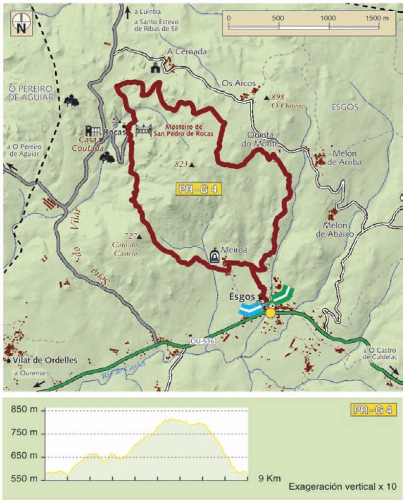
We should highlight the Meiroá ánimas (shrine), but particularly the Monastery of San Pedro de Rocas, a historical-artistic monument foun-ded in the year 573.
The monastery gives impressive views over the Rocas Manor and a huge conifer forest that climbs uphill towards the rocky peaks that give it its name (Rocas), brought about by geological agents acting upon this area.
Access
A plus
MONASTERIO DE SAN PEDRO DE ROCAS
The monastery’s Pre-Romanesque building is remarkable, both on account of the beauty of its location and integration in the natural setting and because of its constructive originality. 13thcentury man knew how to benefit from natural forms sculpted by erosion without destroying them; rock and architecture give shape to three chapels with a floor burrowed by numerous anthropomorphic tombs. The bell-tower stands directly on a large outcrop. This monastery, founded in the 6th century by ascetics, reminds us that we are in the A Ribeira Sacra.
The petos de ánimas (shrines to hold ex-votos) such as the one in Meiroá, are small stone constructions, very frequent in Galicia, bearing witness to a deeply-rooted cult of the dead and devotion to souls. Located at roadsides or crossroads, they vary in design. The petos hold religious imagery (mainly scenes from purgatory) with a money-box for making offerings and giving charity for the souls of deceased loved ones.
Longitude
Point of Departure / Arrival
Route
Difficulty
Duration
Equipment
Services
M.I.D.E.
Bicycle access
Horse access
cartography I.G.N. (1:25:000)
Further information
Oficina de Información Turística de Esgos
Tel.: 988 372 020
info@concelloesgos.com
www.concelloesgos.com
Kind of route
Interest
Map


