Turismo de Galicia


-
Things to do
Way of St. James
Nature
Culture and heritage
Beaches and coast
Tourist trails
- Top ten: Ten unrivalled destinations
- The route of the camellia
- Tourist routes
- Pathways for discovering a country
- Walks to fall in love with
- Greenways
- Scenery at the wheel
- EuroVelo Galicia
- Beyond the Sunset
Gastronomy
Health tourism
PROMOTIONS TO ENJOY NOW
Cultural agenda
Will happen... View all
- Places to visit
-
Plan your trip
Build your journey
Practical information


-
A miña viaxe
A MIÑA VIAXE
- Compartir
- Correo
- Imprimir
mailto:?subject=Content from Tourism of Galicia: PR-G 77 SENDA DE BOBORÁS&body=I recommend you read the information PR-G 77 SENDA DE BOBORÁS extracted from the Tourism of Galicia site on page https://www.turismo.gal/recurso/-/detalle/200430000176/pr-g-77-senda-de-boboras?ctre=23%26langId=en_US%26tp=6

Datos do recursos turístico
Description
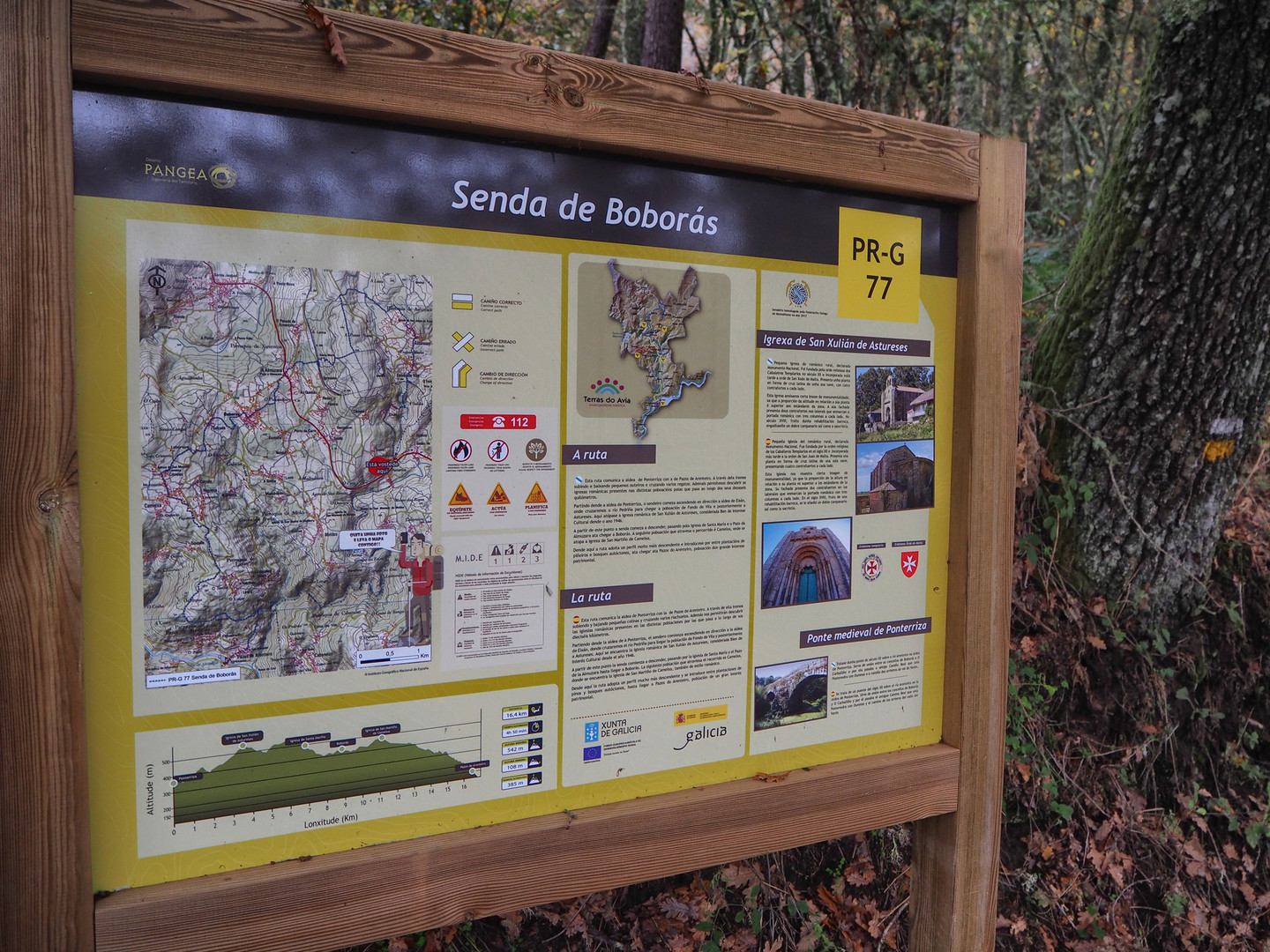
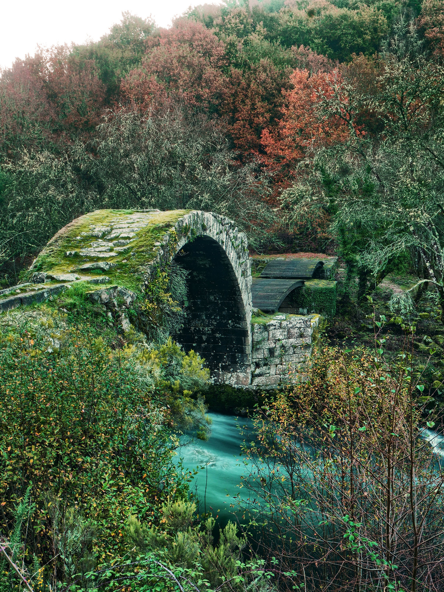
The start is on the road that connects Eixán with Ponterriza. Despite not being on the route, this last village is worth visiting thanks to its mediaeval bridge and a crucerio (cross) with serpent engravings. In Ponterriza there is also the possibility to connect to PR-G 79. The path reaches Eixán and descends to cross the Pedriña river, then begins the ascent towards Astureses.
The heritage that we find on this PR-G is very significant. You can find examples of Romanesque architecture in the churches of San Xulián de Astureses, Sta. María de Xuvencos and San Martiño de Cameixa and the Almuzara country house (rural tourism).
At the end of the journey, the route descends towards the ruins of Leborín and leads to the village of Pazos de Arenteiro between beautiful paths flanked by ancient walls (see PR-G 76). From this town you can take the PR-G 79 towards Ponterriza, 8 km away, passing through Castro Cavadoso and Moldes and, in this way, complete the circular route.
Access
A plus
O Ribeiro and
O Carballiño, stone made into art
The territory of
the regions of O Ribeiro and O Carballiño has a significant amount of religious
heritage. To the aforementioned Romanesque route (churches of Astureses,
Xuvencos and Cameixa), we must add those of San Mamede de Moldes (also in
Boborás), San Tomé de Serantes, Lamas, Lebosende and Gomariz (in Concello de
Leiro) and that of San Tomé O Vello in Maside, not forgetting the
pre-Romanesque church of San Xes de Francelos in Ribadavia.
Other more recent, but equally unique, temples are those of Carballeda de Avia, Castrelo de Miño, Beade, Banga and O Carballiño. To complete this, the monasteries of Oseira, Melón and San Clodio shape an essential route for any curious traveler.
Longitude
Point of Departure / Arrival
Route
Difficulty
Duration
Connections
With PR-G 76 and 79.
Services
M.I.D.E.
Bicycle access
Horse access
cartography I.G.N. (1:25:000)
Further information
www.terrasdoavia.es
Kind of route
Map

