Turismo de Galicia


-
Things to do
Way of St. James
Nature
Culture and heritage
Beaches and coast
Tourist trails
- Top ten: Ten unrivalled destinations
- The route of the camellia
- Tourist routes
- Pathways for discovering a country
- Walks to fall in love with
- Greenways
- Scenery at the wheel
- EuroVelo Galicia
- Beyond the Sunset
Gastronomy
Health tourism
PROMOTIONS TO ENJOY NOW
Cultural agenda
Will happen... View all
- Places to visit
-
Plan your trip
Build your journey
Practical information


-
A miña viaxe
A MIÑA VIAXE
- Compartir
- Correo
- Imprimir
mailto:?subject=Content from Tourism of Galicia: MARINA PUNTA LAGOA&body=I recommend you read the information MARINA PUNTA LAGOA extracted from the Tourism of Galicia site on page https://www.turismo.gal/recurso/-/detalle/36567/marina-punta-lagoa?ctre=117%26langId=en_US%26tp=66

Datos do recursos turístico
Location
Parish: Teis (San Salvador)
Street: Baixada á Lagoa s/n
36207 Vigo - Pontevedra
The Ways of St. James
Navigation
Vigo’s location in the estuary offers the best conditions for housing a port that, for many years, has led the way in the amount of fish off-loaded. The produce arrives here frozen from the four corners of the Atlantic, from the fishing grounds of Newfoundland, Gran Sol, the Falklands or Namibia.
The city, which began as a fishing village, has become the most populated in Galicia, with successive extensions taken back from the sea. Neighbourhoods such as O Berbés or Bouzas retain their maritime flavour beside the large commercial and ocean liner quays.
Vigo enjoys the sun on the beaches of Samil and Canido. The main destination of day runs on the estuary are the Cíes Islands, the jewel of Galicia’s Atlantic Islands National Park, which offer beautiful sunsets.
Galicia’s largest city offers more than one excellent viewpoint, without leaving the city centre: parque do Castro is a good place.
Approaching from the S, sail based on the light from the lighthouse on the Cíes Islands (Gp Fl(2)W 8s 187m 22M) and from Cabo Silleiro (Gp Fl(2+1)W 15s 82m 24M). Once the latter is to starboard, sail past the buoy on Boeiro islet (Gp Fl(2)R 8s 23m 5M) and W compass point (Gp Al(9)W 15s 5M) on the As Serralleiras islets. Once situated, sail along the 069º leading line of cape Stay (ant Iso W 2s 18m 18M and 660 m post from the ant Oc W 4s 50m 18M) until you are opposite the light on Lameda point (Gp Fl(2)G 8s 29m 5M) and cape Vicos (Gp Fl(3)R 9s 94m 10M). Once situated, sail bearing 040º based on the light on the Tofiño shoal (Gp Fl(4)G 14s 11m 5M) and on Borneira rock (Gp Fl(2)R 7s 13m 7M) until the light from the lighthouse at Nuestra Señora de la Guía Hermitage (Gp Oc(2+1)W 20s 37m 15M) is visible off the starboard bow. Then sail towards it until you see the light (Q G 1s 2M) on the Marina Punta Lagoa jetty right off the prow, leaving all of the lights from the Vigo commercial and fishing port off the starboard side.
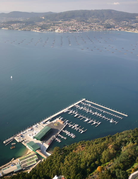
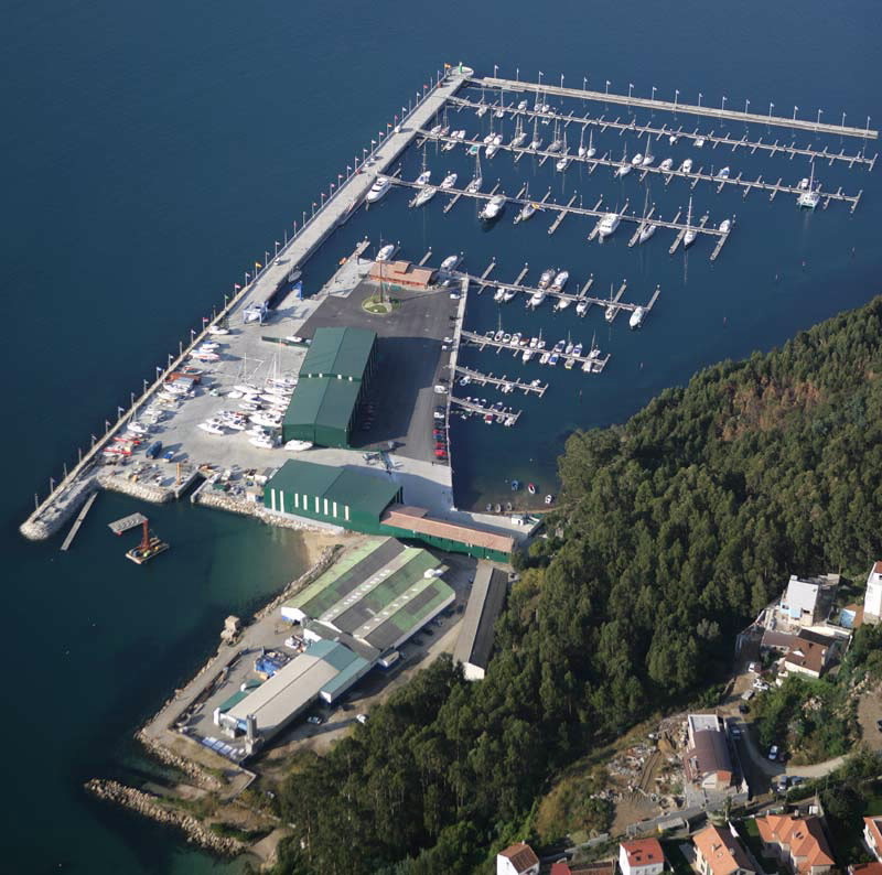
To reach the port, enter the estuary through the S channel (the main one), following the course established by the lighted Cabo Stay leading line. Once past the Punta Lameda – Cabo Vicos opposition line, set a course of 041º, as indicated by the leading line between the Borneira tower/marker buoy (S of Cabo Balea) and the tower on Rodeira beach and the Domaio mountain/lighthouse. Once you have Toralla Island off the starboard beam, adjust your course to pass the Tofiño shoal marker buoy to starboard, at which point you will be able to see the facilities at Vigo’s commercial port. At the end of them, beneath Monte de Guía, you will find Marina Punta Lagoa.
