


mailto:?subject=Content from Tourism of Galicia: CANÓN DO SIL (A RIBEIRA SACRA)&body=I recommend you read the information CANÓN DO SIL (A RIBEIRA SACRA) extracted from the Tourism of Galicia site on page https://www.turismo.gal/recurso/-/detalle/16954/canon-do-sil-a-ribeira-sacra-?langId=en_US
CANÓN DO SIL (A RIBEIRA SACRA)

Datos do recursos turístico
Location
A Pobra do Brollón | Carballedo | Chantada | Monforte de Lemos | O Saviñao | Pantón | Ribas de Sil | Sober
OurenseA Peroxa | A Teixeira | Castro Caldelas | Montederramo | Nogueira de Ramuín | Parada de Sil
Description
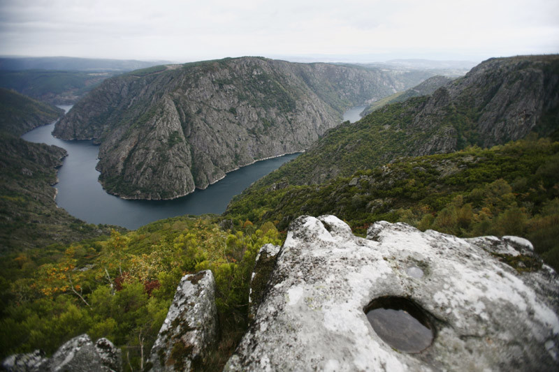
The river erosion of the Sil gradually carved out the deep channel that directs it until it flows into the Miño on the left. Monks and hermits sought refuge on its impossible sides and with secular patience built about a dozen monasteries, most of them Romanesque and Benedictine, which date from the Middle Ages of Rivoyra Sacrata.
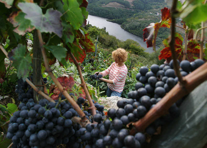
Although this is one of the best natural spaces, defined by its two great rivers, nobody knows exactly where the Ribeira Sacra begins and ends. It could be that its true limits are set by the presence of the vines on the sunny slopes. Here the Mandi wines are produced. They were already regarded as excellent in the times of the Roman Empire, and are backed up today by the D.O. product qualification.
The monasteries were secularized and the waters were pooled in successive dams, but the strength of the land continues to be apparent in every harvest of its fruits. Admire the difficult grape harvest on the steep slopes which can only be cultivated in terraces, the best example of a slowly humanized landscape.
Wildest nature finds its place in the granite outcrops covered by thickets and chestnut and oak forests. The unusual climate conditions of the most protected areas favour the presence of Mediterranean species, such as cork and strawberry trees. The high rocky outcrops of the gorges have often been mentioned as one of the last refuges of the most threatened birds of prey.
Access
The Ways of St. James
Situation
Area
Services
Food: Yes..
Without missing
One of the most spectacular ways of getting to know the Ribeira Sacra is by water. The two courses are navigable in a catamaran, the Sil from the Ourense jetties of Santo Estevo (Nogueira de Ramuín) and Abeleda (Castro Caldelas) and the Miño from the Lugo town of Belesar (O Saviñao). The tourist routes run through the heart of the region itself.
The monasteries closest to the river Sil are those of Santo Estevo de Ribas de Sil and Santa Cristina. The first, converted into a hostel, is reached from Luíntra (Nogueira de Ramuín) or, if we want to take a longer road, by way of the monastery of San Pedro de Rocas (turnoff on the OU-536 in Tarreirigo, Esgos). The Interpretation Centre of the Rocas monastery, regarded as the best in Galicia, gives the visit an added value. There is a direct road to and from Parada de Sil going to Santa Cristina. The path down to this monastery goes through thickets of centuries-old trees. From Parada de Sil, a short dirt path goes to the so-called “Balcón de Madrid”. This is a breathtaking lookout point over an abyss, from where the shrine of Cadeiras (Sober) can be seen on the other bank and the Monforte plain on the horizon. There are no lack of lookout points, like the structure between Vilouxe and Caxide where the gorge reaches its greatest height. From Castro Caldelas, from whose castle one can look out over the countryside, a winding road makes its way through the secret places of the Ribeira Sacra.
Singular nature
Information and facilities
Map

