Turismo de Galicia

-
Things to do
Way of St. James
Nature
Culture and heritage
Beaches and coast
Tourist trails
- Top ten: Ten unrivalled destinations
- The route of the camellia
- Tourist routes
- Pathways for discovering a country
- Walks to fall in love with
- Greenways
- Scenery at the wheel
- EuroVelo Galicia
- Beyond the Sunset
Gastronomy
Health tourism
PROMOTIONS TO ENJOY NOW
Cultural agenda
Will happen... View all
- Places to visit
-
Plan your trip


-
A miña viaxe
A MIÑA VIAXE
- Compartir
- Correo
- Imprimir
mailto:?subject=Content from Tourism of Galicia: MACIZO CENTRAL&body=I recommend you read the information MACIZO CENTRAL extracted from the Tourism of Galicia site on page https://www.turismo.gal/recurso/-/detalle/17001/macizo-central?langId=en_US%26tp=1%26ctre=9

Datos do recursos turístico
Description
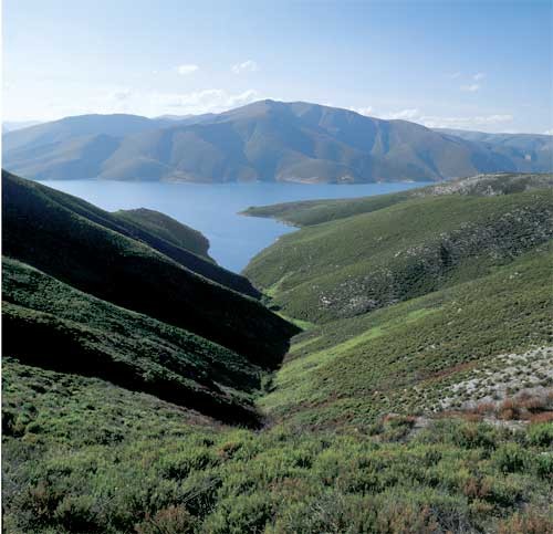
This is a land exposed to the slow changes of nature and tradition. For example, the century-old chestnuts that renew their sweet, tender fruits year after year, or Roman bridges that can still be crossed by cars. This is what the inner province of Ourense looks like, with summits bringing together the rough enchantment of the stone and the sweetness of huge rounded volumes. The highest point of the Serra de Queixa is the only Galician winter sports resort, Manzaneda. To be more precise, in A Cabeza Grande (1.782 m). There are some additional alpine landscapes in the Serra de San Mamede (1,619 m) and O Fial das Corzas, where hills surround the O Invernadeiro Natural Park. The rivers having their source in these hills are tributaries of the Sil northwards; of the Miño through the cheerful Arnoia westwards; and southwards, there are rivers that flow into the Douro (Duero), now in Portugal.
We can therefore say that this is an important water domain, but somehow contrasting: sometimes abundant and sometimes scarce, according to seasons, height and orientation. Located just under 200 kilometres from the coast, it is one of the areas that register the highest amount of waterfalls in the form of snow and rain. But the summers are dry. The yearly average temperature does not exceed 10º. The river Bibei, which defines this massif up to its mouth in the Sil, creates a narrow mountain pass in classic Mediterranean style. Vine growing is typical of this landscape.
FLORA: Oak woods (Quercus pyrenaica). Birch wood (Betula alba) in Montederramo, together with carballeiras. Holly bush (Ilex aquifolium) and European mountain ash (Sorbus aucuparia). On the summits, pasture lands of Festuca indigesta and broom such as Cytisus scoparius and C. purgans.
FAUNA: Wolf (Canis lupus), Golden Eagle (Aquila chrysaetos),Weasel (Mustela nivalis), Brown Partridge (Perdix perdix hispaniensis). In the O Invernadeiro Park, ungulated species: Roebucks (Capreolus capreolus), Fallow deers (Dama dama)and Deers (Cervus elaphus).
M.A.N.: Nature Room in the N.P. "O Invernadeiro" and administrative permits to visit the park: Phone number. 988 386 376. Five guided routes. Wild Fauna Recovery Centre. Alto do Rodicio.
SERVICES: In the villages of the SCI "Macizo Central".
routes
Any visit to the O Invernadeiro Natural Park requires an administrative permit, which allows daily access to thirty people at most, but there are also five excellent guided routes with excellent didactic opportunities. Roebucks and deers coming down to the river can be watched. Originally, it was a game preserve, but now it is often visited by school groups looking for contacts with nature.
The best way to approach the Natural Park is from Verín, through the road that leads to Campobecerros. Access is more difficult from Vilariño de Conso, the municipality where the Park is located. But from here we can also walk through other paths.
One leads to Chaguazoso, the highest hamlet in Galicia. Then, you can cross the river and, downstream, enjoy the view of a wild waterfall. A different walk will take you to Pradoalbar where a spectacular valley is bathed by the river Cerveira, whose name changes to Conso further on. If you want to walk around the Central Massif sierras, the road from A Pobra de Trives offers wonderful footpaths. You can climb to the winter sports resort of Manzaneda. From this place, other tracks lead to the granite-shaped structures, or to the summit of A Cabeza Grande, and then to the abandoned hamlet of Prada, on an old glacier.
If, on the contrary, you walk to the municipality of Chandrexa de Queixa through Celeiros, the municipal head town with an ethnographical museum, there is a road that runs around the dam from which several turn-offs start, as well as a nice walk to the recreational area of Santa Cruz along the banks of the river Queixa. From here, you can also reach the "Bidueiral de Montederramo" SCI and have a look at the woody stronghold dominated by perfectly-preserved birches.
However, if you want to climb the Serra de San Mamede, we recommend starting onthe other side. From the village of Arnuíde, on the road from Maceda to Xinzo de Limia, a track which starts there will lead you to the hill where blueberry bushes grow.
On the other end, on the lands of O Bolo, the typical photo of the Bibei river mountain pass should include the baroque sanctuary of As Ermidas, which hangs from the mountain among slopes filled with vineyards. The mild climate even allowed the monks to have a mill for making olive oil.
