routenameKmlevel of difficulty
1Santa Mariña Route26,4 Km
2Terra do Millo Route19,8 Km
3Foxo Vello Route15,1 Km
4Os Lagarteiros Route11,4 Km
5Monte Covelo Route7,5 Km
6Parroquia de Parada Route23,6 Km
7Casas da Veiga e Vilar de Santos Route12,8 Km


RELATED DOCUMENTS...

R1 - Santa Mariña Route

This route’s various paths and roads, coupled with its rich heritage, make it one of the most unmissable routes in the Área de Allariz.
On this route, you will often cross paths with pilgrims walking towards Santiago via the “Vía de la Plata” (“Silver Way”). The route leaves Allariz heading North towards Roiriz. It leads to Armeá, a tiny enclave teeming with history, located next to Santa Mariña de Augas Santas and its church. The temple-basilica and the Castro de Armeá (Armeá Celtic Settlement), where some stone warriors were found and are now housed in the Ourense Archeological Museum, were declared to be Historic-Artistic Sites. Worth visiting is the crypt known as “Os Fornos”, where tradition says that Santa Mariña became a martyr, condemned to burn to death and saved by the divine intervention of San Pedro.
Before you set off on the last stretch of this route, it is recommended that you visit the Ecoespazo O Rexo in Requeixo de Valverde, famous for its sculptures and images by Basque artist Agustín Ibarrola on trees and large stones from the river Arnoia.
The route returns to Allariz via an appealing riverside route along the river Arnoia.


start pointCamping Os Invernadeiros
42º 11`5.34” N  / 7º 49´ 5.27” W
 max. heightaltitude difference (+)distanceconnection/s
643 m482 m26,4  km 
fi nish pointCamping Os Invernadeiros
42º 11`5.34” N  / 7º 49´ 5.27” W
min. heightaltitude difference (-)timedifficulty
425 m482 m2h 40´


RELATED DOCUMENTS...

R2 - Terra do Millo Route

This route is almost 20 kilometres long, and forms a pyramid shape. A gradual ascent takes us away from the city of Allariz to the south, with the tarmacked streets gradually being replaced by forest tracks.

This cycle route reaches an altitude of 857 metres, this being the highest point of the whole MTB Centre network. This intersects with Route 6 “Parroquia de Parada”, which connects this route with others in the Vilar de Santos section.

In Penamá you can replenish your water from a well in the middle of the village. This is not the only opportunity you have to satiate your thirst; San Martiño de Pazó offers water and the possibility of visiting its Church, which is now a Site of Cultural Interest (BIC).

The last section is nearly entirely all downhill, via A Portela, until it reaches the left bank of the river Arnoia to return to the starting point in the municipal campsite.


start pointCamping Os Invernadeiros
42º 11`5.34” N / 7º 49´ 5.27” W
 max. heightaltitude difference[+]distanceconnection/s
857 m574 m19,8 km R6
finish pointCamping Os Invernadeiros
42º 11`5.34” N / 7º 49´ 5.27” W
min. heightaltitude difference[-]timedifficulty
422 m574 m2h 00 min

RELATED DOCUMENTS...

R3 - Foxo Vello Route

This route is almost 20 kilometres long, and forms a pyramid shape. A gradual ascent takes us away from the city of Allariz to the south, with the tarmacked streets gradually being replaced by forest tracks.
This cycle route reaches an altitude of 857 metres, this being the highest point of the whole MTB Centre network. This intersects with Route 6 “Parroquia de Parada”, which connects this route with others in the Vilar de Santos section.
In Penamá you can replenish your water from a well in the middle of the village. This is not the only opportunity you have to satiate your thirst; San Martiño de Pazó offers water and the possibility of visiting its Church, which is now a Site of Cultural Interest (BIC).
The last section is nearly entirely all downhill, via A Portela, until it reaches the left bank of the river Arnoia to return to the starting point in the municipal campsite.


start pointCamping Os Invernadeiros
42º 11`5.34” N  / 7º 49´ 5.27” W
 max. heightaltitude difference (+)distanceconnection/s
675 m310 m15,1 km 
finish pointCamping Os Invernadeiros
42º 11`5.34” N  / 7º 49´ 5.27” W
min. heightaltitude difference (-)timedifficulty
425 m310 m1h 30´


RELATED DOCUMENTS...

R4 - Os Lagarteiros Route

WARNING: This route cannot be done due to the impossibility of crossing the river at one point.

This is the only route in this sector that does not pass through the city of Allariz.
Leaving the campsite, you cross a curious wooden bridge over the river, next to some stepping stones. After 3 kilometres uphill, you reach the vicinity of Outeiro de Orraca, where the journey continues in the direction of the parish of Queiroás.
Alternating between quiet dirt tracks, tarmacked road and cultivated fields, the last stretch leads us back to the river Arnoia, via an old road. The route crosses the river over a stone bridge, a fine example of the richness of popular Galician architecture.
The return route is shared with Route 2 “Terra do Millo” and you end the journey the same way you began, enjoying the picturesque riverside scene formed by the river and the surrounding flora.


start pointCamping Os Invernadeiros
42º 11`5.34” N  / 7º 49´ 5.27” W
 max. heightaltitude difference (+)distanceconnection/s
568 m190 m11,4 km 
finish pointCamping Os Invernadeiros
42º 11`5.34” N  / 7º 49´ 5.27” W
min. heightaltitude difference (-)timedifficulty
422 m190 m1h 10´


RELATED DOCUMENTS...

R5 - Monte Covelo Route

This shorter version of Route 6 “Parroquia de Parada” is suitable for mountain, touring or gravel bikes. This route is an alternative way to enjoy a small cycle route that starts at the Reception Point, located around the Vilar de Santos swimming pool, and goes around the base of Mount Covelo.
This route is mainly made up by compacted dirt tracks that facilitate smooth cycling. From Castelaus you can admire the different landscapes of the A Limia region, made up of what is known as chaira, a plain with extensive crop fields, and a more mountainous area characterized by rounded contours. Less than 1 kilometre from this point is the fork that allows you to continue on Route 6 “Parroquia de Parada” and opt for a longer and more challenging route.
The journey continues to ascend into the neighbouring municipality of Sandiás. From here, the path’s steep decline leads to a stretch that combines natural stone paths with a more verdant ones.
The remains of the old windmill of O Ruxidoiro and a crossing over a small stream indicate proximity to the centre of Vilar de Santos and the return route to the Reception Point.


start point Casa do Concello de Vilar de Santos
42º 5´ 14.58” N  / 7º 47´ 39.46” W
 max. heightaltitude difference (+)distanceconnection/s
727 m166 m7,5 km R6
finish point Casa do Concello de Vilar de Santos
42º 5´ 14.58” N  / 7º 47´ 39.46” W
min. heightaltitude difference (-)timedifficulty
622 m166 m45´


RELATED DOCUMENTS...

RELATED DOCUMENTS...

R6 - Parroquia de Parada Route

This route, which goes into the northern part of the municipality of Vilar de Santos to the border with Allariz, has the same first 2 kilometres and final section as Route 5 “Monte Covelo”.
After leaving Castelaus, the route goes left, in the direction of Parada de Outeiro, where you can quench your thirst at the spring located on the route. The ride continues until it reaches a place known as O Camiño da Brea, surrounded by oak trees and cultivated fields.
After leaving the centre of A Venda, you can appreciate a wide panorama that includes the Baixa Limia-Serra do Xurés Nature Reserve, the O Mediodía peak and the Larouco mountain range in the background.
Setting off on the path again, the route follows through a fairly comfortable terrain until it reaches the northernmost point of the municipality of Vilar de Santos at the ninth kilometre, where you can join routes from the Allariz section.
In Laioso you can visit the chapel of San Xoán and stop at the “Fonte da Lama” (“Lama Fountain”) to recuperate before ascending to Cantarinas peak. The way to the summit is signposted; you will need to leave the main route and go up a steep slope to reach the peak.
The last 10 kilometres are characterised by a rugged relief, which include two small ascents before returning to Vilar de Santos.


start pointCasa do Concello de Vilar de Santos
42º 5´ 14.58” N  / 7º 47´ 39.46” W
 max. heightaltitude difference (+)distanceconnection/s
854 m577 m23,6  km 
fi nish pointCasa do Concello de Vilar de Santos
42º 5´ 14.58” N  / 7º 47´ 39.46” W
min. heightaltitude difference (-)timedifficulty
622 m577 m2h 20´


RELATED DOCUMENTS...

RELATED DOCUMENTS...

R7 - Casas da Veiga e Vilar de Santos Route

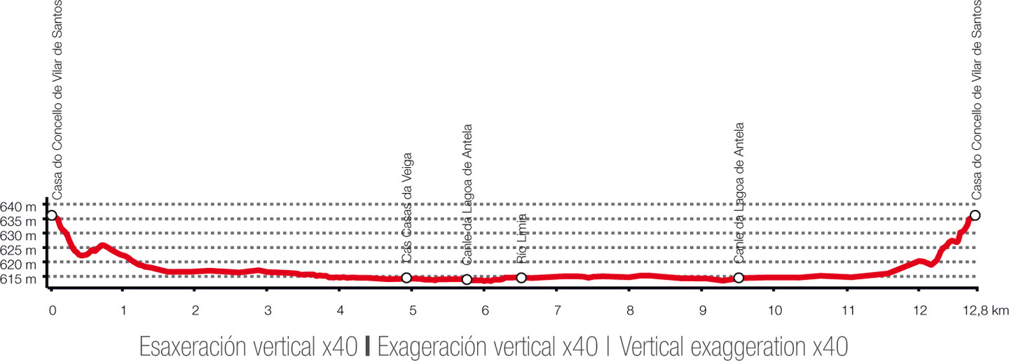
A very family-friendly route that is completely flat and runs along the length of the Antela Lagoon’s main channel, a natural space that is now protected by virtue of the fact that it is a ZEPA (Protected Birdlife Reserve).
You can take a mountain, touring or gravel bike along this route, thanks to the terrain.
The compacted dirt tracks and the absence of traffic allow you to calmly cycle along, taking in the natural environment. Only the beginning and end of the route cross a road, and there is sufficient visibility at these points.
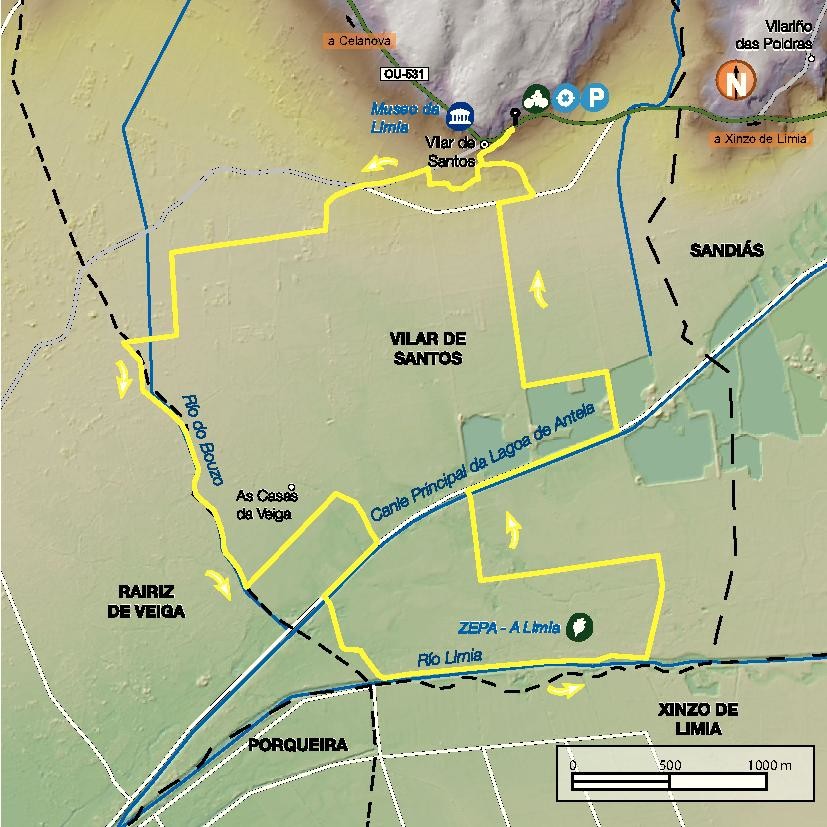
For the most part, the route runs along where the Vilar de Santos municipality borders the adjacent municipalities of Sandiás, Xinzo de Limia, Porqueira and Rairiz de Veiga.
The route goes around the Antela Lagoon, which was one of the largest wetlands on the Iberian Peninsula until it was completely drained in the 1960s, where some aggregate mining is still operating. It is an ideal place for bird watching, and you can use the informative panels located along the route to help you with this. A large part of the exhibition at the Museum of A Limia is dedicated to this place, which continues to be considered mythical by the whole region.
It is important to remember that, due to the proximity of some of the mining operations, the rules and any instructions given by operators must be followed. Bathing is prohibited throughout the protected area.


start point Casa do Concello de Vilar de Santos
42º 5´ 14.58” N  / 7º 47´ 39.46” W
 max. heightaltitude difference (+)distanceconnection/s
637 m20 m12,8 km 
finish point Casa do Concello de Vilar de Santos
42º 5´ 14.58” N  / 7º 47´ 39.46” W
min. heightaltitude difference (-)timedifficulty
637 m20 m1h 20´


RELATED DOCUMENTS...

RELATED DOCUMENTS...

Arriba