


1. GPX
GPX or GPS eXchange Format (GPS exchange Format) is an XML scheme designed to transfer GPS data between applications and online Web services.
GPX or GPS eXchange Format (GPS exchange Format) is an XML scheme designed to transfer GPS data between applications and online Web services.
It can be used to describe points (Waypoints), tracks (tracks), o routes (routes).
Main advantages of GPX:
There is no specific program for the transfer of GPX; there are several programs that can be used:
Here, the steps to follow for transferring GPX files using G7ToWin and EasyGPS will be described.
G7ToWin is an executable programs that allows you to introduce files in GPX or GPS format and convert GPS data to GPX format.
There are several versions of G7ToWin depending on requirements:
The software is compatible with Windows 95, 98, Me, XP, Vista.
If you have a computer with another non-Windows operating system, one of the programs that you can use is GPSBabel.
G7ToWin is a free program that can be downloaded from the website: http://www.gpsinformation.org/ronh/g7towin.htm
Installation is very simple, just download the correct version and decompress it into a PC directory. Since it is an executable file, it is not necessary to install it on the computer, just execute the g7towin.exe file and the program will open.
Some of the GPS devices that are compatible with G7ToWin are: Garmin, Eagle, Lowrance and Magellan.
On the Turgalicia website there are points of interest files available to download in GPX format. This format is applied to the G7ToWin program, following the process described below.
Connect the GPS to the computer using a USB cable.
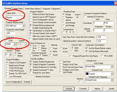
The GPS is configured in the option: File Configuration.
A new window will appear where in the general tab you must assign the GPS, the USB and the speed.
Load the points of interest file onto the GPS by following the instructions below:
Downloading GPX files: Decompress and save the GPX files information from the Turgalicia website in a locatable place on the computer.
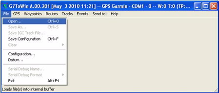
Loading points of interest: Once the program is installed and you have checked that the GPS configuration is correct, you can incorporate the POI into the program. This is done from the main menu: File Open.
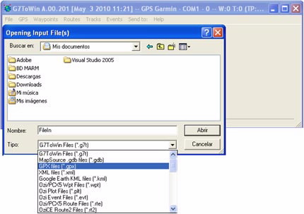
Locate the POI by choosing the GPX file type
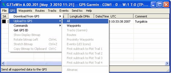
Incorporating the points of interest onto the GPS: once the POI are loaded into the program they can be moved onto the GPS by selecting the option: GPS, Upload to GPS, All
Once the POI are loaded onto the GPS you can close the program and unplug the GPS from the USB cable. When the GPS is switched on, the POI will appear.
The EasyGPS lets you transfer waypoints and routes from the computer to the GPS device.
EasyGPS only works with Windows Vista and XP operating systems; and it only transfers data with .gpx or .loc extensions.
GPS devices compatible with EasyGPS: Becker, BlackBerry, Brunton, Cobra, DeLorme, Eagle, Furuno, Garmin, Holux, HTC, Humminbird, Jensen, Lowrance, Magellan, Medion, Mio, MLR, Navigon, Navman, Nextar, Nokia, Pharos, Satmap, Silva, Sony, Thales and Tom Tom.
On the Turgalicia website there are points of interest files available to download in GPX format. This format is applied to the EasyGPS program, following the procedure described in this tutorial.
Once the program is installed, connect the GPS to the computer using a USB cable.
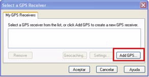
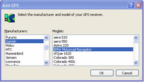
When you open the EasyGPS application, it will ask you about the GPS receiver, in order to assign the GPS type and model. Click on Add GPS.
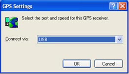
When you click OK, another window will appear where you assign the GPS connection method, for example USB.
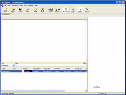
Loading the POI: To enter the GPX files in the program click on File, Open. Search for the downloaded .gxp files.
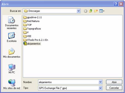
Once the file is opened, it will appear in the lower part of the program.
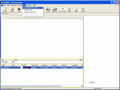
Importing the GPX file onto the GPS: this can be done in two ways:
From the main GPS menu, Send to GPS
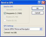
A menu will open where the number of points to be sent and the GPS model and type are listed. If everything is correct, click on OK.
Or, from the send icon (![]() ).
).
In this case, a window will also appear with the information to be sent. If everything is correct, click on OK.
Once the procedure is completed, you can disconnect the GPS. Once the GPS is switched on, the points of interest will be included on the device.
The GPSBabel program allows for the conversion of more than 140 file formats to be able to work with them in different programs for editing and processing geographical information and different GPS receiver models.

