Turismo de Galicia
Menú Idiomas
-
Que facer
Camiño de Santiago
Natureza
Cultura e Patrimonio
Mar e Costa
Rutas
- Top-Ten: Dez lugares únicos
- Ruta da camelia
- Rutas turísticas
- Sendas para descubir un país
- Paseos que namoran
- Vias Verdes
- Escenarios ao volante
- EuroVelo Galicia
- Alén do solpor
Gastronomía
Turismo de Saúde
Promocións para disfrutar agora
Axenda cultural
Vai pasar... Ver todos
- Que visitar
-
Planifica a túa viaxe
mailto:?subject=Envio de contido de Turismo de Galicia: PR-G 141 RUTA DO OURO E DO CAMIÑO REAL&body=Recoméndoche que leas a información PR-G 141 RUTA DO OURO E DO CAMIÑO REAL extraída do portal de Turismo de Galicia na páxina https://www.turismo.gal/recurso/-/detalle/277249708/pr-g-141-ruta-do-ouro-e-do-camino-real?tp=6%26ctre=23
No Camiño de Santiago
Datos do recursos turístico
Descrición
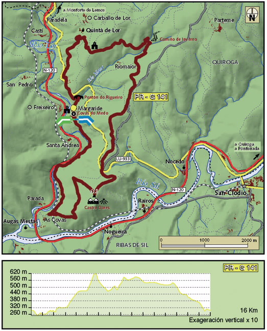
Esta ruta circular comeza na aldea de Margaride, ao lado do antigo complexo mineiro coñecido como
Covas do Medo.
Ascendemos por un estreito sendeiro, próximo á vía do tren, ata alcanzar a aldea das Covas. Dende este punto unha pista forestal ha levarnos ata unha dura subida; na súa cima atópanse os restos de Castro Dares e un miradoiro que ofrece unha espectacular panorámica do río Sil, o val de Quiroga e os cumes que o arrodean.
Tras repoñer forzas neste privilexiado lugar, a ruta acomete pequenas baixadas e suaves pendentes ata enlazar co trazado do coñecido como Camiño Real, sinalizado como Camiño de Inverno.
Dende aquí continúase polo norte da aldea de Riomaior. En dirección ao Carballo de Lor chégase ao Pontón do Rigueiro, unha antiga ponte restaurada recentemente que conserva o seu deseño orixinal e que nos ha conducir de volta a Margaride a través do vello Camiño da Misa.
Acceso
Na N-120 que une Ourense con Ponferrada, tomar a
LU-5003 que leva a Margaride.
Camiños de Santiago
Camiño de Inverno
Un plus
CAMIÑOS REAIS
Construídos pola Coroa Española, aproveitando en moitas ocasións antigas calzadas romanas para o tránsito de persoas, mercadorías e gando. Eran vías para comunicar as diferentes áreas do país, tamén coñecidas como «camiños de ferradura», por estaren empedradas para facilitar o traballo das bestas de carga.Nestes camiños instaláronse sinais para marcar as distancias percorridas en légoas, herdanza do sistema miliario romano, así como outros elementos que facían máis confortable o camiño como fontes, bancos de pedra, reloxos de sol e establecementos de comidas.
O tramo do Camiño Real deste percorrido aparece documentado en diferentes escritos como ruta de entrada a Galicia dende Ponferrada. Ruta xa empregada polos romanos, que máis tarde se converteu nunha derivación do Camiño Francés de peregrinación a Santiago de Compostela.
Lonxitude
16 km.
Punto de partida/chegada
Covas do Medo en Margaride (Quiroga) - UTM:29T X:636629 Y:4704680
Percorrido
Covas do medo, Castro Dares, Camiño Real, Riomaior,
Pontón do Rigueiro, Covas do Medo.
Dificultade
Media - Alta
Duración
5 horas e media.
Servizos
Fóra da ruta, na N-120, no lugar do Conceado, a 1,5 km
de Margaride.
M.I.D.E.
Esforzo M.I.D.E.:
Itinerario M.I.D.E.:
Desplazamento M.I.D.E.:
Medio M.I.D.E.:
Acceso en bicicleta
Apto totalmente
Acceso a cabalo
Apto totalmente
Cartografía I.G.N. (1:25:000)
189-II Quiroga.
Máis información
Concello de Quiroga
Tel.: 982 428 001
concello.quiroga@eidolocal.es
www.concellodequiroga.com
Federación Galega de Montañismo
Tel.: 986 208 758 / Fax: 986 207 407
sendeirismofgm@yahoo.es
www.fgmontanismo.com
Segatur (Sendeiros de Galicia para o Turismo Rural S.L.)
Tel. 654 165 730 / 886 117 011
info@segatur.com
www.segatur.com
Tipo de percorrido
Pequeno percorrido
Interese
Interese xeral
Descargue as coordenadas do recurso que lle presentamos...
Plano

Data de recollida inicial: 01/08/2019


