Turismo de Galicia

-
Que facer
Camiño de Santiago
Natureza
Cultura e Patrimonio
Mar e Costa
Rutas
- Top-Ten: Dez lugares únicos
- Ruta da camelia
- Rutas turísticas
- Sendas para descubir un país
- Paseos que namoran
- Vias Verdes
- Escenarios ao volante
- EuroVelo Galicia
- Alén do solpor
Gastronomía
Turismo de Saúde
Promocións para disfrutar agora
Axenda cultural
Vai pasar... Ver todos
- Que visitar
-
Planifica a túa viaxe


mailto:?subject=Envio de contido de Turismo de Galicia: RÍA DE AROUSA&body=Recoméndoche que leas a información RÍA DE AROUSA extraída do portal de Turismo de Galicia na páxina https://www.turismo.gal/recurso/-/detalle/9691/ria-de-arousa?tp=3%26ctre=14

Datos do recursos turístico
Descrición
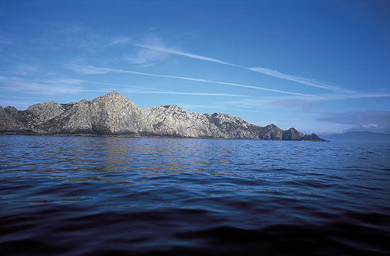
A ría de Arousa é a máis extensa das Rías Baixas.
A súa boca ábrese entre as puntas Covasa, ao norte, e San Vicente, ao sur. Máis rectangular cás súas veciñas, debido á súa orixe de bloque afundido, ofrece formas contrastadas. Polo norte, limítaa nitidamente a serra da Barbanza e, polo sur, aparece bordeada polas suaves terras aplanadas do Salnés.
No seu interior son numerosas as illas e illotes de extraordinaria beleza, entre as que destaca a illa de Sálvora, na súa entrada, a Illa de Arousa, no seu sector central e a de Cortegada, no seu fondo, no contacto coa desembocadura do río Ulla, por terras de Carril. Precisamente, esta última foi doada a comezos do século XX para residencia do rei Alfonso XIII.
O perfil sinuoso de Arousa propicia a existencia dun gran número de enseadas e penínsulas que favoreceron o asentamento de numerosas vilas mariñeiras, como Aguiño, Ribeira, A Pobra do Caramiñal, Boiro e Rianxo, na vertente norte; e Carril, Vilagarcía, Vilaxoán, Vilanova, Cambados e O Grove, na sur. Na confluencia co río Ulla, Catoira e, no centro da ría, a vila da illa de Arousa.
Atopámonos nunha área na que se combina a beleza natural co desenvolvemento económico, aínda que non sempre en harmonía coa arte e a tradición. Do primeiro son exemplo as súas illas, as súas numerosas praias, as serras do seu contorno, como a da Barbanza, ou os tramos inferiores dos ríos que desembocan na ría, como o das Pedras, o Ulla ou o Umia, sen esquecer o marabilloso complexo lagunardunar de Corrubedo, na actualidade parque natural, e que se atopa na península que separa as rías de Arousa e Muros-Noia.
A amplitude da ría de Arousa propiciou que dende antigo fose unha vía aberta ás invasións, como o demostran as Torres de Oeste, en Catoira, levantadas para a defensa do río Ulla do ataque dos normandos e dos árabes, pero tamén para o comercio.
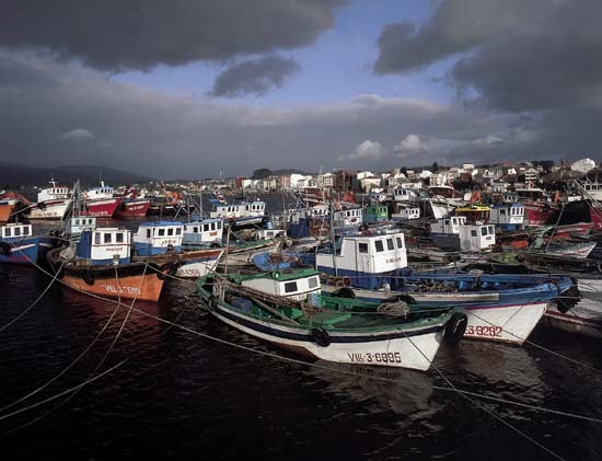
Dende o punto de vista económico, hai que salientar que a riqueza de Arousa non se reduce ao sector marisqueiro, á pesca, á acuicultura ou á industria conserveira. Tamén é de grande importancia o sector vinícola, onde destaca o Albariño, sen dúbida dos mellores brancos do mundo.
Primeiro Carril e, máis tarde, Vilagarcía de Arousa, foron localidades que coñeceron un desenvolvemento económico extraordinario, dado que actuaron como os portos de Santiago e das súas terras, Vilanova de Arousa e Cambados, na mesma ribeira sur, xunto con Rianxo, Boiro, A Pobra do Caramiñal e Ribeira, situadas na norte, desenvolvéronse máis recentemente.
Vilagarcía de Arousa é un importante porto comercial e pesqueiro de extraordinaria actividade económica, que relevou a inmediata Carril do papel promotor que exercera ata o século XIX. Centro neurálxico da comarca do Salnés, é famosa polo seu viño con denominación de orixe Rías Baixas.
No Salnés tamén sobresae Cambados, vila señorial na que se poden ver casas brasonadas ou a extraordinaria praza de Fefiñáns, flanqueada polo pazo dos Figueroa e a igrexa de San Benito, século XVI. Trátase dun lugar dos que se deben percorrer a pé para desfrutar del. Ademais, é a capital do Albariño.
Situada na ribeira norte, A Pobra do Caramiñal é unha vila señorial con casas brasonadas e castelos, como as Torres da Xunqueira. Flota sobre a vila a sombra inmortal de Valle-Inclán, o seu cantor.
E, na mesma ribeira, atopámonos con Santa Uxía de Ribeira, cidade de extraordinario pulo económico fundado no sector da pesca. No seu interior, conserva algúns restos da vella vila mariñeira, e moi preto atópase Corrubedo.
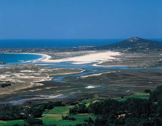
No parque natural de Corrubedo é posible observar a combinación de diferentes elementos.
Bordeando o mar, a extensa praia, na que resaltan algúns cumes graníticos. Se camiñamos cara ao interior atopamos, en primeiro lugar, un sistema dunar fixado pola vexetación, no que resaltan formas pinaculares; despois, un amplo corredor intradunar e, a continuación, a duna móbil que, cun quilómetro de lonxitude e uns vinte metros de altura, se move ritmicamente impulsada polos ventos do suroeste e do nordés. Este xogo de ventos fai que a súa mobilidade se vexa circunscrita a un espazo moi concreto, sen que se produzan grandes desprazamentos.
Traspasada a duna móbil, esténdese, por un lado, un amplo manto eólico e, cara ao nordés, a área hidromorfa da lagoa de Carregal que, coa de Vixán, situada un pouco máis ao sur, se converten en lugares de grande interese faunístico, sobre todo ornitolóxico.
A súa boca ábrese entre as puntas Covasa, ao norte, e San Vicente, ao sur. Máis rectangular cás súas veciñas, debido á súa orixe de bloque afundido, ofrece formas contrastadas. Polo norte, limítaa nitidamente a serra da Barbanza e, polo sur, aparece bordeada polas suaves terras aplanadas do Salnés.
No seu interior son numerosas as illas e illotes de extraordinaria beleza, entre as que destaca a illa de Sálvora, na súa entrada, a Illa de Arousa, no seu sector central e a de Cortegada, no seu fondo, no contacto coa desembocadura do río Ulla, por terras de Carril. Precisamente, esta última foi doada a comezos do século XX para residencia do rei Alfonso XIII.
O perfil sinuoso de Arousa propicia a existencia dun gran número de enseadas e penínsulas que favoreceron o asentamento de numerosas vilas mariñeiras, como Aguiño, Ribeira, A Pobra do Caramiñal, Boiro e Rianxo, na vertente norte; e Carril, Vilagarcía, Vilaxoán, Vilanova, Cambados e O Grove, na sur. Na confluencia co río Ulla, Catoira e, no centro da ría, a vila da illa de Arousa.
Atopámonos nunha área na que se combina a beleza natural co desenvolvemento económico, aínda que non sempre en harmonía coa arte e a tradición. Do primeiro son exemplo as súas illas, as súas numerosas praias, as serras do seu contorno, como a da Barbanza, ou os tramos inferiores dos ríos que desembocan na ría, como o das Pedras, o Ulla ou o Umia, sen esquecer o marabilloso complexo lagunardunar de Corrubedo, na actualidade parque natural, e que se atopa na península que separa as rías de Arousa e Muros-Noia.
A amplitude da ría de Arousa propiciou que dende antigo fose unha vía aberta ás invasións, como o demostran as Torres de Oeste, en Catoira, levantadas para a defensa do río Ulla do ataque dos normandos e dos árabes, pero tamén para o comercio.
Dende o punto de vista económico, hai que salientar que a riqueza de Arousa non se reduce ao sector marisqueiro, á pesca, á acuicultura ou á industria conserveira. Tamén é de grande importancia o sector vinícola, onde destaca o Albariño, sen dúbida dos mellores brancos do mundo.
Primeiro Carril e, máis tarde, Vilagarcía de Arousa, foron localidades que coñeceron un desenvolvemento económico extraordinario, dado que actuaron como os portos de Santiago e das súas terras, Vilanova de Arousa e Cambados, na mesma ribeira sur, xunto con Rianxo, Boiro, A Pobra do Caramiñal e Ribeira, situadas na norte, desenvolvéronse máis recentemente.
Vilagarcía de Arousa é un importante porto comercial e pesqueiro de extraordinaria actividade económica, que relevou a inmediata Carril do papel promotor que exercera ata o século XIX. Centro neurálxico da comarca do Salnés, é famosa polo seu viño con denominación de orixe Rías Baixas.
No Salnés tamén sobresae Cambados, vila señorial na que se poden ver casas brasonadas ou a extraordinaria praza de Fefiñáns, flanqueada polo pazo dos Figueroa e a igrexa de San Benito, século XVI. Trátase dun lugar dos que se deben percorrer a pé para desfrutar del. Ademais, é a capital do Albariño.
Situada na ribeira norte, A Pobra do Caramiñal é unha vila señorial con casas brasonadas e castelos, como as Torres da Xunqueira. Flota sobre a vila a sombra inmortal de Valle-Inclán, o seu cantor.
E, na mesma ribeira, atopámonos con Santa Uxía de Ribeira, cidade de extraordinario pulo económico fundado no sector da pesca. No seu interior, conserva algúns restos da vella vila mariñeira, e moi preto atópase Corrubedo.
No parque natural de Corrubedo é posible observar a combinación de diferentes elementos.
Bordeando o mar, a extensa praia, na que resaltan algúns cumes graníticos. Se camiñamos cara ao interior atopamos, en primeiro lugar, un sistema dunar fixado pola vexetación, no que resaltan formas pinaculares; despois, un amplo corredor intradunar e, a continuación, a duna móbil que, cun quilómetro de lonxitude e uns vinte metros de altura, se move ritmicamente impulsada polos ventos do suroeste e do nordés. Este xogo de ventos fai que a súa mobilidade se vexa circunscrita a un espazo moi concreto, sen que se produzan grandes desprazamentos.
Traspasada a duna móbil, esténdese, por un lado, un amplo manto eólico e, cara ao nordés, a área hidromorfa da lagoa de Carregal que, coa de Vixán, situada un pouco máis ao sur, se converten en lugares de grande interese faunístico, sobre todo ornitolóxico.
